Tuesday, June 10, 2025

OE/SB-268 Gaisberg

 After a rainy night, the morning dawned overcast but dry. Our original plan was to take the bus and cable car to Untersberg, but the weather wasn't looking that great. So instead we had a relaxing morning walking around Salzburg before heading to the mountains in the afternoon.

Gaisberg, as seen from the old town.

After a bit of an adventure obtaining bus tickets, we got on the 151 bus to Gaisberg. Our plan was to take the bus most of the way up, and walk the final bit. After a few stops in town, the bus started climbing. Near the bottom of the mountain, at a stop by a large field, dozens of paragliders got on with their equipment, heading up for another flight. I was glad I didn't have to drive up the narrow road. It was entertainment enough watching the bus driver navigate it.

Hiking up through the forest.

We decided to get off at the penultimate stop. This was about a kilometer and a few hundred meters below the summit. The trail was well worn, and it didn't take too long to get to the summit. The top is well built up, with a few buildings and the large tower that can be seen from town.

Looking down at Salzburg.

We watched some paragliders take off, then found a spot to eat lunch and play radio. All the shady benches were taken, so we tried sitting on the ground. This didn't last long, however, since there was an army of ants waiting for us. On a sunny bench we enjoyed our cheese and bread, then I got on the air. There was cell service on top, which helped a lot since the bands were only in slightly better shape than the evening before. I made five contacts before stopping.

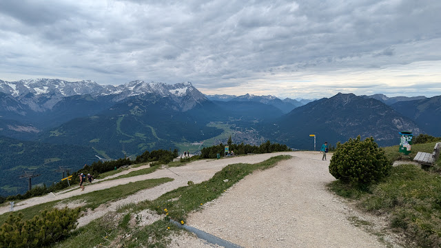
View in another direction.

The bus pulled up as we were finishing packing up, so we decided to just take it down from the summit. It was convenient, and we were soon back downtown. Overall, a pleasant afternoon outing.

Trailhead: One of the bus stops on the 151 line. Or take the bus all the way to the summit. Could also drive or bike up.
Website: SOTA Site.
Route: Take the trail up.
Red Tape: None.
Video: coming soon!

Sunday, June 8, 2025

OE/SB-300 Kapuzinerberg

 It was pouring rain as our train arrived in Salzburg at lunch time, but it slowly slackened, then ended as the afternoon passed. By dinner time, it was pretty pleasant in the old town, perfect for a quick walk up this hill. This summit is just across the river from Old Town, and easy access if you're in the city. Our hotel was only a block away from the starting point.

View from Mozartplatz. Not a very good likeness of Mozart.  

The start is through an arch on Linzer Gasse. There was a small Asian food stand just inside the gate. The first part of the walk up is pretty steep, and there are stairs on the side of the paved road. There were also a number of religious art installations on the side. Stations of the cross maybe? Either way, it seemed like all the art in Salzburg is either religious or Mozart.

Start of the trail.
 

I followed the paved road as it wound up the hill. There are a number of other buildings, and as you get higher, dirt trails branch off. I took one that my map called the Nordweg. It was in pretty good shape, not too muddy despite the day's rain, and with plenty of stone or paved steps on anything remotely steep. About halfway up I took a small spur over to a viewpoint to get the view looking north.

Salzburg.
 

It was dark in the forest, with the sun setting and mostly hidden behind clouds. There is another building just below the summit. Just above the building, in a small clearing, I found OE2HRO packing up after his activation. I said hi, then found a different spot to set up. It only took a minute to get the KH1 on the air and calling CQ.

OE2HRO and OE/AA6XA
 

The bands, however, were not in good shape. In about 30 minutes of operating I only made one contact. It was disappointing, but I could see rain moving in, so I didn't want to stay to try and get three more. I was packed up and partway down the hill before the first drops started falling. To get down I just followed the paved road the whole way. I'm not sure it was any better than the route I took up.

View of the fortress through the trees.

Trailhead: Intersection of Linzer Gasse and Stefan-Zweig-Weg, at the arched gateway. This is on the west side of the mountain.
Website: SOTA Site.
Route: Follow the paved road to the top. Or turn off and take one of the dirt trails. There are plenty to choose from.
Red Tape: None.
Video: coming soon!

Sunday, May 18, 2025

W7N/TR-027 Captain Pomin Rock

 If you at Tahoe in the winter do you go skiing? No, of course not. It is the perfect season to go get some SOTA activating in. After leaving very early and driving up from the Bay Area, we stopped in town to pick up some snowshoes. It was then a few more minutes around the lake to the trailhead.

First steps in snowshoes!

We started at Spooner Summit snow park, at the intersection of US 50 and NV 28. There was a decent size parking lot, and a nice hill for sledding. It was Naina's first time snowshoeing, so after we got them on we took an easy walk along the road until we found the track to the summit. There were a few sets of footprints to follow.

Heading up the hill.
 

The forest was open, and the hill wasn't too steep. It was windy, but we were on the lee side of the hill. Ideal conditions for winter hiking. It took a few minutes to re-acquaint myself with snowshoe walking, but we were soon making good time up the hill. The trail climbs up to a relatively flat area, which it crosses, then has a final climb up to the summit.

Summit photo.

The very final climb was quite steep, and it wasn't obvious which way was best to the top. I followed some other tracks and was able to get up without needing to take off the snowshoes. That was probably the only part of the hike that would have been easier in the summer. 

As we suspected, the wind was really blowing on top, so after a few pictures we retreated into the forest for a quick activation. Thankfully there were enough chasers I could get enough contacts before we got cold.

Hard to get tired of lake views.
 

One the way down we decided to take a shortcut, and go straight back to the car from the flat area. This was easy, since any brush was well buried under the snow and we were going down hill. Summer hikers might make a different choice. Back at the car, the parking lot had filled to capacity with sledders, who we watched while eating lunch. 

Enjoying the view from South Lake Tahoe.

Trailhead: Spooner Summit snow play area.
Website: SOTA Site.
Route: Winter: just go straight up to the summit.
Red Tape: None.

Saturday, March 29, 2025

W7N/CK-115 Black Mountain

 We were in Las Vegas for Christmas, so I decided to do an early morning activation. This peak seemed like a good choice, with a parking area and trails to the summit. I started before dawn so I could be back in time for the day's other activities. From the parking area, the trail is paved until you reach a small dam. I went around the small reservoir, which was empty, and made my way to the Sloan 404 Trail. 

Black Mountain before sunrise.

This connects to the north trail that goes up Black Mountain. It was steep and rocky, but I made good time as dawn came. There are some sections that are steep, but nothing crazy. At the top it turns into some class 2 scrambling. The sun had come up at this point, and I was glad it had. It would have been difficult to get through the ridge walk in the dark. I did manage to trip on a rock and cut my leg pretty good, but other than that it was just really windy.

Almost at the summit.
 

Once I made it over to the summit, I quickly found a place out of the wind and got my radio set up. It was cold, and I didn't want to stay any longer than I needed to. Thankfully there were enough people awake on Christmas for me to get four contacts pretty quickly. I packed up and headed down.

Trying to stay warm in the wind.

To go down, I made it a loop and took the main Black Mountain trail. This is quite steep at the top, but after that relatively short section it is very runnable with lots of switchbacks. It was warmer out of the wind, but I was on the shady side of the mountain so it took a while before I warmed up again. Back at the car it had turned into a beautiful day, and I drove back to the hotel to get ready for the day's adventures.

Looking back at the peak.

Trailhead: Parking area on Shadow Canyon Drive
Website: SOTA Site.
Route: Take the Black Mountain Trail and/or the Black Mountain North Trail to the summit and back.
Red Tape: None.


Thursday, January 23, 2025

W6/SD-267 Copper Mountain

 It was our last day in Joshua Tree, and I wanted to get another summit before leaving. This peak, between Joshua Tree and Twenty-nine Palms, fit the bill. Copper Mountain has some towers on top, and therefore a dirt road leading to the summit. I parked in the flat area, near the intersection of Mantonya Road Siesta Drive. Siesta continues up to the summit.

Dawn in the desert

It was just about dawn as I started up the road, and I was slowed by the constant need to turn around to enjoy the sunrise. The road was in pretty good shape, and I could have driven my sedan farther up. But that was hard to tell in the dark, so I just walked a bit extra. Siesta Dr goes up a canyon for a ways, then onto the side of the hill. On the steeper sections the road was quite rutted, and high clearance would be necessary to drive up.

Heading up the canyon
As I got onto the summit, the sun came over the horizon. It was great watching the light change on the far away mountains and the desert floor. It seems like the natural summit of the mountain has been flattened, as there was a very large area on top near the towers. I set up on the edge of this, away from the towers. Since it was sunrise, I was hoping to get some European stations in the log, but the bands must not have been open. Either way, I made plenty of QSOs as I enjoyed the sunrise.
KH1 on the summit.

Before heading down I tagged the other summit, with more towers, just to be sure I had touched the high point. I then took the same road back down to the car, a quick jog. From there is was a few minute drive back to the hotel and breakfast.

Not only are desert sunsets nice, but the sunrises too.
       

Trailhead: As far up Siesta Dr as you're willing to drive
Website: SOTA Site.
Route: Follow Siesta Drive up the canyon to the top.
Red Tape: None

Desert art near the town of Joshua Tree. This one is call "Transmission"

Friday, January 10, 2025

W6/SD-166 Bartlett Mountains High Point

 We had driven down to Joshua Tree for a few days in the area. There was some time before we had to head into the park to catch the sunset, so I decided to go for a quick activation. This peak was only a few minutes away from the hotel and was a short hike. 

Looking over at the summit.
I drove up Yucca Mesa Road, then turned east onto Sun Mesa Drive. I was hoping to be able to drive to the end, but there was a sign indicating the road was private past Alta Ave. So I turned around and parked near that intersection. The shortest way to the top would be up Sun Mesa, but I didn't want to go up that road. So I headed one block south to Sun Oro Road and went down that way. The road goes past a few houses, then ends at a turn-around. It looks like the area is popular, since there was trash and a fire pit at the end. 
Its pointy-er from this direction

There isn't a trail from the end of the road, but it was easy to find my way up to the top of the ridge in front of me. On the crest of this ridge is a jeep trail, which heads towards the now visible summit. After a short distance it turns into single track, then starts getting harder to follow. On the way up I lost the trail for a while, but came across it again after a short time. 

Joshua trees along the road.

There are some switchbacks on the way up, and before you know it, you're at the summit. The highest point is on the far side of the ridge, so I went over there to set up. I wanted a quick activation, so I just used the KH1 and whip. Sadly, there was loud noise on all the bands I checked. I'm not sure where it was coming from, since there isn't anything on the summit. Maybe a nearby solar array or something. Either way, I was able to make my four contacts.

Desert sunsets are the best.

Heading down I was able to follow the trail better back to the jeep road. Back on the road it was a quick walk back to the car and to the hotel. I picked up my wife, and we found a nice spot inside the park to watch the sun set. Joshua Tree is a great place for sunsets.

Such a beautiful park.

 
Trailhead: Intersection of Sun Mesa Dr and Alta Ave.
Website: SOTA Site.
Route: Follow Sun Oro Rd to the end, then cross country to the trail that leads to the summit.
Red Tape: None. Watch out for road closed signs.