Tuesday, June 10, 2025

OE/SB-268 Gaisberg

 After a rainy night, the morning dawned overcast but dry. Our original plan was to take the bus and cable car to Untersberg, but the weather wasn't looking that great. So instead we had a relaxing morning walking around Salzburg before heading to the mountains in the afternoon.

Gaisberg, as seen from the old town.

After a bit of an adventure obtaining bus tickets, we got on the 151 bus to Gaisberg. Our plan was to take the bus most of the way up, and walk the final bit. After a few stops in town, the bus started climbing. Near the bottom of the mountain, at a stop by a large field, dozens of paragliders got on with their equipment, heading up for another flight. I was glad I didn't have to drive up the narrow road. It was entertainment enough watching the bus driver navigate it.

Hiking up through the forest.

We decided to get off at the penultimate stop. This was about a kilometer and a few hundred meters below the summit. The trail was well worn, and it didn't take too long to get to the summit. The top is well built up, with a few buildings and the large tower that can be seen from town.

Looking down at Salzburg.

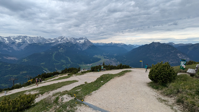
We watched some paragliders take off, then found a spot to eat lunch and play radio. All the shady benches were taken, so we tried sitting on the ground. This didn't last long, however, since there was an army of ants waiting for us. On a sunny bench we enjoyed our cheese and bread, then I got on the air. There was cell service on top, which helped a lot since the bands were only in slightly better shape than the evening before. I made five contacts before stopping.

View in another direction.

The bus pulled up as we were finishing packing up, so we decided to just take it down from the summit. It was convenient, and we were soon back downtown. Overall, a pleasant afternoon outing.

Trailhead: One of the bus stops on the 151 line. Or take the bus all the way to the summit. Could also drive or bike up.
Website: SOTA Site.
Route: Take the trail up.
Red Tape: None.
Video: coming soon!

Sunday, June 8, 2025

OE/SB-300 Kapuzinerberg

 It was pouring rain as our train arrived in Salzburg at lunch time, but it slowly slackened, then ended as the afternoon passed. By dinner time, it was pretty pleasant in the old town, perfect for a quick walk up this hill. This summit is just across the river from Old Town, and easy access if you're in the city. Our hotel was only a block away from the starting point.

View from Mozartplatz. Not a very good likeness of Mozart.  

The start is through an arch on Linzer Gasse. There was a small Asian food stand just inside the gate. The first part of the walk up is pretty steep, and there are stairs on the side of the paved road. There were also a number of religious art installations on the side. Stations of the cross maybe? Either way, it seemed like all the art in Salzburg is either religious or Mozart.

Start of the trail.
 

I followed the paved road as it wound up the hill. There are a number of other buildings, and as you get higher, dirt trails branch off. I took one that my map called the Nordweg. It was in pretty good shape, not too muddy despite the day's rain, and with plenty of stone or paved steps on anything remotely steep. About halfway up I took a small spur over to a viewpoint to get the view looking north.

Salzburg.
 

It was dark in the forest, with the sun setting and mostly hidden behind clouds. There is another building just below the summit. Just above the building, in a small clearing, I found OE2HRO packing up after his activation. I said hi, then found a different spot to set up. It only took a minute to get the KH1 on the air and calling CQ.

OE2HRO and OE/AA6XA
 

The bands, however, were not in good shape. In about 30 minutes of operating I only made one contact. It was disappointing, but I could see rain moving in, so I didn't want to stay to try and get three more. I was packed up and partway down the hill before the first drops started falling. To get down I just followed the paved road the whole way. I'm not sure it was any better than the route I took up.

View of the fortress through the trees.

Trailhead: Intersection of Linzer Gasse and Stefan-Zweig-Weg, at the arched gateway. This is on the west side of the mountain.
Website: SOTA Site.
Route: Follow the paved road to the top. Or turn off and take one of the dirt trails. There are plenty to choose from.
Red Tape: None.
Video: coming soon!