It was a beautiful spring afternoon as I set out to climb Maguire Peaks in the Sunol Regional Wilderness. The sun was out and the wildflowers were starting to bloom.
 |
| There were a few poppies blooming. |
I started from the trailhead on Welch Creek Road. This is a very narrow road, so drive carefully. The trail quickly climbs up into the open grassland that dominates the area. There had been some rain the previous week, so some sections were muddy, but overall it was much dryer than the activations in January and February. I took the Maguire Peaks Trail, then turned left onto the Maguire Peaks Loop. At the ridge on the West side of the mountain is a well worn herd path that leads to the summit. Some maps also show a trail heading up from a bench on the north side, but I have not looked for it.
 |
| The peak on the left. |
 |
| Mt Allison (W6/NC180) and Mission Peak. |
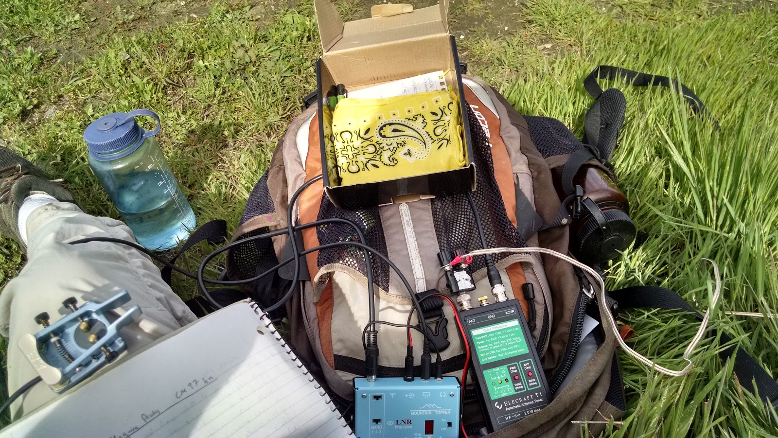
At the summit there are some low trees, but you will probably want to bring a pole to hold up your antenna. I set up and got on 20 meters. Once again, there were not many contacts to be had here. It was late afternoon, around 3:30 local, so 20 might have been closed to the east, where all the chasers are. 30 meters once again provided the majority of the contacts, 10/13. I did manage one on 40 as well.
 |
| Operating position and antenna pole. |
I spotted myself on VHF, but did not get any contacts here. I was surprised, there were line of sight views north to Pleasanton/Livermore, and over to the Peninsula. I guess this means its time to make a roll up j-pole. Overall I made only 13 contacts, many with the usual chasers. I need to learn their names so I can thank them better on the air.
 |
| Calling CQ. |
I packed up and headed back the way I came. The sun was low in the sky, softening the light and making for a very pretty descent. I passed through a herd of cows that weren't there on the way up, and I didn't remember seeing any, so I'm not sure where they came from. Sunol is one of my favorite parks in the Bay Area, and spring is the best time to come. This makes this peak one of the best in the area, I think.
 |
| The herd path follows this ridge down to the trail. |
 |
| Trailhead. With careful parking you could probably fit 3 cars here. |
Maps: http://www.ebparks.org/parks/sunol, map at the bottom. Also KB1KXL SOTA Hikes map
Route: From the trailhead (6), head uphill, staying on the Maguire Peaks Trail. At the intersection with the Maguire Peaks Loop (8), go left (clockwise). At the prominent ridge on the west side of the mountain, find the herd path, or bushwhack to the top. There are cliffs on the south side, so approaches from the south probably won't work.
Red Tape: Ask for a Welch Creek Road permit at the main entrance station. You still have to pay the $5 park entrance fee, but the special permit is free. This also requires some backtracking, but is better than getting a big fine. The permit is only required on weekends.
Very nice! Regarding parking on Welch Creek Road, and the fee, I believe neither of those is necessary if you go on a weekday (as I did, over the holiday break in December).
ReplyDeleteI remember reading that somewhere, but I can't find the reference.
DeleteYeah, I called and talked with a ranger before I went.
Delete