Wednesday, August 14, 2024

W6/WH-008 Peak 10942

 This peak is the easiest in the White Mountains, by far. The main road goes around the peak just below the summit. However, the only nearby parking is to the south, at the last switchback below the peak. We parked here.

Radio set up at the summit.

From the pullout, it was about a five minute walk up to the top. I was pretty out of breath despite spending the night at 8000 feet. I guess it takes more that eight hours to acclimate.

Pointing at tomorrow's goal, White Mountain Peak.

There was good cell service on top, and the bands were open. We shared a KX2 so we could eavesdrop on all the QSOs. It was a quick and easy activation.

Bristlecone Pines.

We didn't spend too long on top since we wanted to get another peak or two before heading to the end of the road. We were feeling good and hopeful, so we decided to try and get Station Peak next.

Trailhead: Last switchback south of the peak.
Website: SOTA Site.
Route: Head straight up the hill to the summit.
Red Tape: None.
Video: Coming Soon!

W6/ND-037 Lookout Mountain

 KE6MT, N6RUN, and had decided to go to the White Mountains for some peakbagging and SOTA. In order to acclimate a little, we left after work on Thursday and drove through Yosemite to spend the night on top of Lookout Mountain. I was around 11:30pm when we arrived at the turn off from 395, and with Rex's SUV we quickly made it to the top. 

Trying a midnight activation.

It was a bit hard to see, but my guess is a sedan would've had a lot of trouble getting up to the summit. There were a few rough or sandy sections. We put up our tents, then quickly put up an antenna. Saurabh called CQ for a while, but only got two contacts. Since it was late, we went to bed after deciding to just get our contacts in the morning.

Sierra in the background.

In the morning I woke up first and got on the air. Since it was light across North America, it was easy to get contacts and I quickly got a dozen or so. As the other took their turns, I packed up and made breakfast. Once we all had our contacts and had finished packing up, we headed back down the hill and on to Bishop.

Despite a few trees, the views were excellent.

At the Great Basin Bakery, we met up with Adam K6ARK who was in town for his own trip. Properly fueled with tasty sandwiches, we headed into the White Mountains and our next summit, Peak 10920.


Trailhead: None, just drive to the summit. Turnoff is across from the Mammoth Scenic Drive north entrance.
Website: SOTA Site.
Route: Pick your favorite spot and set up!
Red Tape: None.
Video: Coming Soon!

Wednesday, July 31, 2024

W6/SS-269

 This is one of three SOTA peaks in the Kaiser Wilderness above Huntington Lake. After some staring at a map, I decided the easiest approach was to drive up to Kaiser Pass, then follow the ridge. This is broadly what we did.

About to enter the wilderness.

The road gets pretty narrow and windy on the way up to the pass, so be prepared for that. There was plenty of parking at the pass, and even some bathrooms. Much cushier than I expected. Heading up the hill we passed a few campfire rings, then the sign marking the wilderness boundary. The slope here is pretty gentle, and it was a pleasant walk through a Sierra forest. On top of the first sub peak we headed down to the col.

Enjoying the view from the open areas.

On the way there we stayed high enough to avoid the marshy meadows. It was probably slightly longer, but having dry shoes made it worth it. The original plan was to get on the ridge and follow it to the summit, but the ridge looked pretty rough. We decided to stay a little below where we only had to walk through calf-high brush. Going was pretty easy, and there weren't any areas we had to fight through.

Huntington Lake.

After you pass around the last sub-peak, you can see the summit above you. This climb was the steepest of the day, but nothing terrible. From below it looks like there are some cliff bands, but the rocks are broken and it was easy to just walk to the summit. From the top the views to the north were excellent, there being a cliff on that side of the mountain. My Verizon phone had ok service, enough to put out some spots. AT&T had some, but not as good.

Making contacts with the new KH1.

The bands were not in good shape, but I managed to get enough on HF with only the KH1 whip. We called on 2m for a while, but there was a station hogging the calling frequency, so we didn't make many there. 

We retraced our steps, more or less, to get back to the car. We stayed a little lower on the ridge during the traverse, and it was just as easy as higher. It did mean, however, we had to cross the wet meadow. Luckily we were able to find enough solid ground to keep our feet dry. Back at the car we coasted down the hill to the general store at the marina to get some snacks and beverages, then back to the campground to relax by the lake.

Trailhead: Kaiser Pass.
Website: SOTA Site.
Route: Head west into the wilderness and follow the ridge around and up to the summit.
Red Tape: None. Permit needed if you want to camp in the wilderness.

Thursday, May 9, 2024

HL/SL-006 Guryongsan

 It was getting close to the end of our time in Korea, but there was still time for one more SOTA activation. We were back in Seoul, so I picked a summit that was easy to get to from the subway. This peak is south of the Gangnam neighborhood, made famous by the song.

The trails were well signed, and seemed pretty popular.

From the Yangjae Citizens Forest station exit 3 I walked south along the road. There is a busy road to cross, then a few buildings, then I stepped into the woods. Based on the maps I was expecting a well marked trail. But instead I found an unmarked, not well used path. It was going the right direction, and in the spot I expected, so I followed it. After a quarter mile or so it intersected with a much nicer path.
Occasional glimpses of the city.

This trail was obviously what I wanted, and what I had been expecting, so I followed it up the ridge. There were a fair number of people out for a hike. Like the other hikes I had done here, it was much more humid than I was expecting. I'm really spoiled living in California. It did feel like it was going to rain, but I never felt more than a few drops.  
Weather station on the ridge.

At one of the intersections there was a big sign telling about the Seoul Trail that circumnavigates the city. It seemed like it could be an interesting thing to do if you lived there. Shortly before the summit is an excellent view point. I stopped for a few pictures before continuing on to the high point. The summit was unremarkable. Just below, near a tower, was a bench I decided to sit at. It was slightly difficult putting up the antenna through the trees, but I managed well enough. On the air I worked Korean and Japanese stations.  
Seoul: Namsan on the left, Lotte Tower, Bukhansan

Once HF was packed up, I walked back to the viewpoint to see if I could get anyone on 2m. I got two more stations, then headed back down. This time I took the nice trail all the way to the bottom, where it came out between a few buildings. It would've been hard to find that trailhead without knowing about it. 
Trailhead: Yangjae Citizens Park subway station, exit 3.
Website: SOTA Site.
Route: Head south along the road, crossing the expressway. In between the buildings there is a trailhead, or the one along the main road. Follow the trail to the summit.
Red Tape: None.
Video: 

Thursday, May 2, 2024

HL/BS-026 Jangsanbong

 During our Korea trip we spent a few days in Busan. This lovely city is nestled among the hills on the southeast coast of the peninsula, and as you'd expect for a hilly city, has some good SOTA opportunities. Naina was in need of a nap, but I had plenty of energy, so I headed out one afternoon for a walk up a local peak. I chose Jangsanbong because it was reasonable close to a subway stop on the 2 line, and our hotel was also on the 2 line.

From Haeundae Beach, I think thats the summit I went to.

We only got one SIM card for the trip, and it was in Naina's phone, so I had to navigate the "old fashioned" way, with just the maps downloaded to my phone. It was not hard, since the phone maps will show you where you are using GPS. I got off the subway at the Kyungsung Univ.-Pukyong Nat'l Univ. stop, then went out exit 3. A u-turn at the top of the stairs then left turn had me heading down the right road.
The summit hiding behind the buildings.

I walked past Pukyong National University, following the main road. At a three way intersection I didn't have to cross, and beared left. Shortly after this there was a busy expressway crossing, so I had to wait for the walk signal. The area on the ocean side of the expressway was much less busy, and felt less built up. The road kept getting smaller and smaller, until it was two lanes with no median. I crossed at a crosswalk shortly before the sidewalk ended.
Helpful(?) map of the park and mountain. I followed the green path, more or less.

As you pass the last buildings, the road gets much steeper. Some meters of climbing later I passed a nice looking building, then a parking lot. There are bathrooms in the building, which was nice, and at the far corner of the parking lot was a trailhead. It was late Sunday afternoon, but the lot was nearly full, and I saw many people out in the park. After a quick glance at a map board, I decided it would be easier to just follow my phone. 
Paved trail on the way up.

The trails in the park had impeccable maintenance. The steep parts were paved or had steps, and the trails were wide. It was nice to be off the city streets. At the top of the first climb, where I got onto the ridge, there was a free outdoor gym. People were using it. This was to become a theme. I followed the main trail up the ridge. Every once in a while there would be a small gap in the trees and a view of Busan, but don't come here if you're expecting views. 
Marker at the summit. I'm not sure what its marking though.

Just below the summit there is a turn off to the high point. I walked through another gym, also in use, to the summit which was an open field. There was a big X in the field, with a path around the perimeter. There are some benches next to the main trail at the junction, in the activation zone, but I decided it would be easier to put up a wire in the open field on top. I used the bushes to hold the pole, and was soon on the air. I thought I'd get a lot of Japanese stations on 40m, but I only got two. I was getting worried as I switched to 20m, but it turns out 20m was probably a better band for getting Japan. I also managed to get a chaser in New Zealand. 
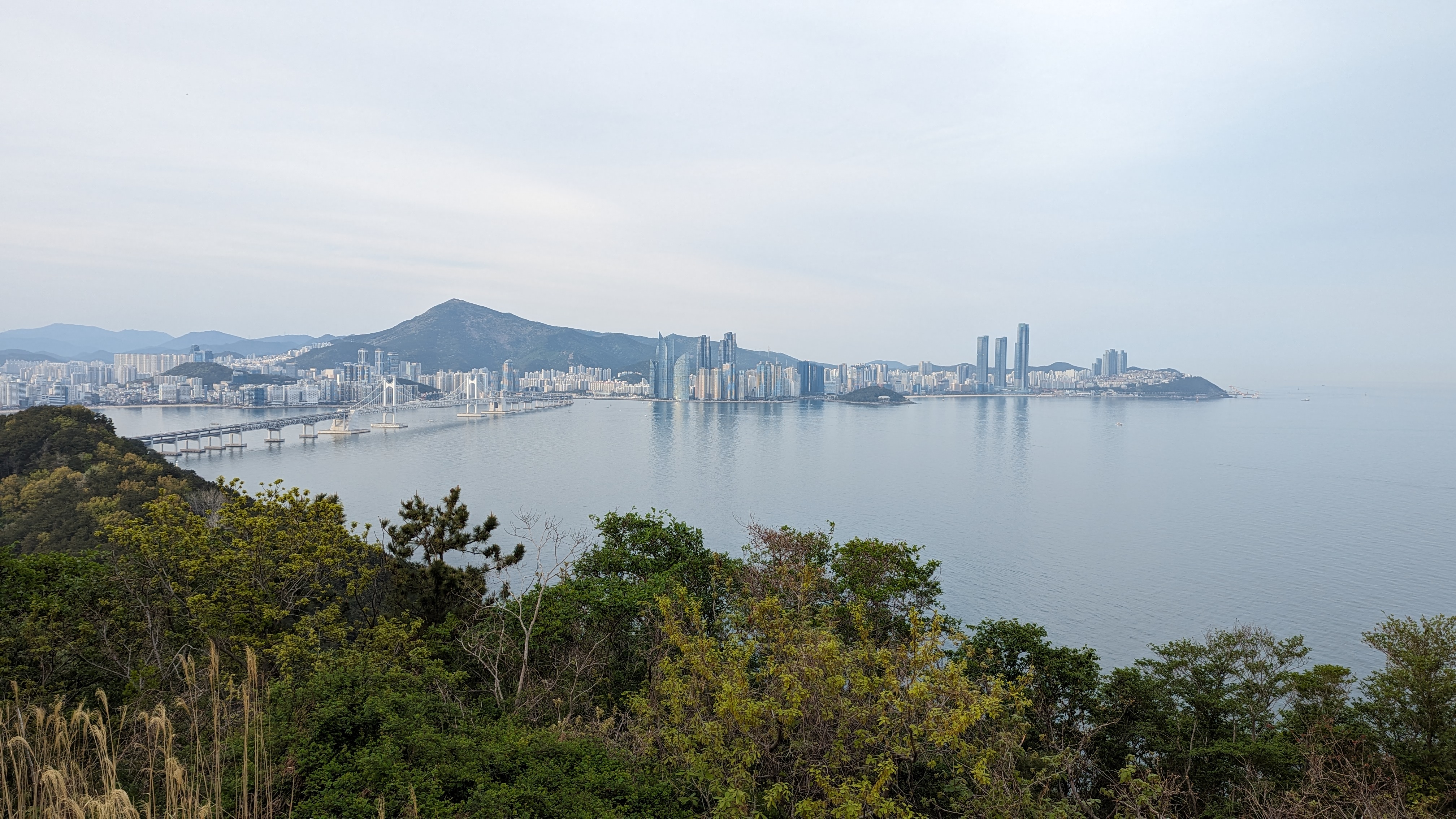
Views of Suyeongman Bay and Busan. Haeundae Beach is on the right, below the three towers.

Once I had packed up I took the same route back down. I passed a viewpoint I had missed on the way up, and that small detour was worth it. The trees had been cleared enough to see the harbor, Hauendae Beach, and parts of downtown. The soft evening light made the scene beautiful. I managed to get through the city, ride the subway, and get back to the hotel just before dark. Though I wasn't too worried once I got to the streets since I knew they'd be lit.
Post-activation soju.

Trailhead: I started at the Kyungsung University stop on subway line 2, but if you have a car you can get much closer.
Website: SOTA Site.
Route: From the Kyungsung University stop on subway line 2, follow the main road towards Pukyong University, across the expressway, and up past the church to the parking lot. Then take the main trail up to the summit.
Red Tape: None.
Video: Coming soon.