Tuesday, December 28, 2021

W1/HA-010 Mt Kearsarge

 The forecast for Christmas eve was looking decent, certainly better than Christmas, so my family decided to go for a hike. Burn off a few of the calories we'd eat the next day, or something like that. We chose to go to Mt Kearsarge, a prominent peak in central NH.

Entrance to the state park.

We hiked in from the north side, which is Winslow State Park. The road to the parking lot is not plowed and gated in the winter, but parking is allowed on the road at the bottom. We parked here, put on our microspikes, and set off up the road.

Heading up the road.

The hike up the road is about a mile to the summer parking lot and trailhead. There were a lot of signs encouraging people to reserve a time, and I can see how the park could get very busy in the summer. We decided to go up the Winslow Trail. I went ahead so I could get set up and operate and not force everyone else to stand around in the cold.

Heading up.

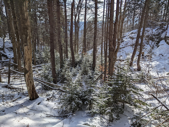
The trail was very icy, and I'm not sure I could have gotten up without the spikes. It must be wet in the summer if there's that much ice. I passed a big group on the way up, with a dog who seemed bored by their slow pace.

A little below the summit.

Near the summit the forest opens up and the trees are all short conifers. The summit has a fire tower and communications tower, and is very open. I looked around and took some pictures, but there was a breeze and it had started snowing lightly, so I turned around to set up in the trees out of the wind.

Excellent views from the summit. In the fall, this must be beautiful.

I set up just above the trail junction below the summit. There was a clearing to the side that I could run my antenna out to and have it out of the way. I started on 20m, hoping to get some good DX, but only got two French stations. However, there was a good size pileup of Americans. Eventually I got cold, but people were still coming back, so I worked them. Before I froze to death, the calls stopped, and I packed up.

Sunny antenna on a gray day.

We took the other trail, the Barlow Trail, back to the parking lot. This trail seemed less steep going down, but still had some icy sections. The road walk back to the gate was much quicker going down. Back at the car we cranked up the heat for the drive back home, happy with our hike.

Trailhead: Winslow State Park. In the winter, park at the gate and walk up.
Website: SOTA Site. Winslow State Park.
Maps: AA6XA SOTA Hikes map.
Route: Take one of the two trails up to the summit.
Red Tape: None. Consider making a reservation in the spring/summer/fall if it is a busy day.
Video: No footage shot.


Sunday, December 26, 2021

W1/HA-212 Dakin Hill

 After activating nearby Osgood Hill, I drove over to the Monadnock-Sunapee Greenway parking lot on NH 9. This is a decent size dirt lot right next to a maintenance station. 

I was the only one on the trail.

Dakin Hill is on the north side of the highway, but luckily there's no need to dodge cars. The stream across the street from the lot flows under the highway in a culvert, and there is a walking path there. It took a minute for me to find the path down, since there were no tracks in the snow.

Walking under the highway.

Once I found the path and made the perilous icy crossing, it was easy to follow the trail. The greenway goes up Nye Road, then follows an old jeep trail from the end of the road. It seems to be on an easement, since both sides were liberally posted by the hunting club who owns the land.

Up the Monadnock-Sunapee Greenway.

I was getting worried as I hiked up that I wouldn't be able to get to the summit since there were so many "Posted" signs. However, they stopped below the summit. At the top of the climb the trail levels out and goes around the summit. I found a good place to step off the trail to bushwhack up to the high point. The forest was fairly open, and I didn't have to weave around too much.

Setup at the summit.

The summit is broad, and I found an open area in the sun to set up. It was pretty warm, which made it more pleasant to operate. I had good cell service on the summit, unlike at the trailhead. The bands were open across the country, and I made plenty of contacts. To get back to the trail, I just followed my footprints down. There were lots of deer tracks on the trail, and only my set of boot prints. This section of the greenway must not be very popular.

Trailhead: Monadnock-Sunapee Greenway parking. Just off Rt 9 on South St, before the maintenance station.
Website: SOTA Site. Monadnock-Sunapee Greenway maps and guides are easy to find online.
Maps: AA6XA SOTA Hikes map.
Route: Cross the highway in the underpass, then follow the white blazes along Nye Road and the jeep trail to the high point. Bushwhack to the summit.
Red Tape: None. Don't trespass.
Video: YouTube

W1/HA-080 Osgood Hill

 I was finally back in New Hampshire for the holidays with family, and one day I had access to the car, so I decided to go do some summits. My plan for the day was Osgood Hill and nearby Dakin Hill. 

Start of the trail. Parking area to the left.

There is a small parking area along Old Stoddard Road. Google marks this point as Kulish Ledges Trail. The road is unpaved, but the sedan made it up. The parking lot was unplowed, and I was a bit worried about getting out if I went in, but it turned out not to be a problem. There's a hornet on a tree marking the parking area and trail.

On the well marked trail.

The trail is flat and easy to follow past a pond to the first junction. I took the left trail here. The first half of the climb is a nice grade, pretty easy walking. The second half is steeper. The trail conditions were good, I didn't need any traction. Near the top of the climb are the Kulish Ledges. There are a few with decent views, and they're the only views on this hike.

Best of the ledge views.

On the summit plateau there is another junction. Follow the sign to the summit. At the summit there is another sign and a bench. The summit area was fairly open, and it was easy to put up and antenna and still sit on the bench.

At the summit!

I set up the radio and got on the air. I had good cell coverage on the summit, and the European stations soon started rolling in. It's always fun getting DX while you're QRP. After about 30 minutes operating I started to get cold, so I packed up and retraced my steps down. The sun had come out, and it was turning into an even nicer day.

Snowy woods.

Back at the car it was no problem getting out and back down to the paved roads, where I drove over to the trailhead for Dakin Hill.

Trailhead: Kulish Ledges Trail, Old Stoddard Road.
Website: SOTA Site.
Maps: AA6XA SOTA Hikes map. Partridge Woods - This site seems out of date, but I can't find any others.
Route: Take the Kulish Ledge Trail to the summit. There are some other trails to make a loop, if desired.
Red Tape: None. Dogs are allowed.
Video: ham_bitious on Youtube

Wednesday, December 1, 2021

More Ways to Follow Me!

If this blog doesn't have enough ham radio content for you, you can also find me on Instagram. My radio account is @aa6xa.radio. It has more SOTA trip reports, as well as other radio related things I've been doing like building things and operating contests.

Since KN6REU got her license, we've stated another account with both our radio stuff, but mostly SOTA: @ham_bitious. She has mastered the art of the reel, and there are a bunch of fun videos up already, with more to come.

And even better, ham_bitious is on YouTube: youtube.com/@hambitious

So come follow for more radio fun!

Antenna setup at Brushy Peak.

Monday, November 15, 2021

W6/SC-215 Panoche Hills High Point

 After activating Peak 2389 with Rex KE6MT and Dan AI6XG, we got back in the car and drove along road P1 to where it intersects with P11. If you're in a sedan, this is where you'll have to park. With some clearance and 4WD you can get closer by driving up P11. In the Pilot, we could get closer. After carefully negotiating a large berm at the intersection, we drove up to the sub-peak.

At the sub-peak, about to hike over.

At the sub-peak, the spur to the summit gets quite rough. We were so close, it wasn't worth trying to drive farther. Since it was such a short hike, we brought Rex's Yaesu 891 so we could run QRO. After putting up the linked dipole we were on the air
Checking out the seismograph station on the top.

Like on the other peak, we each did one band. I started on 2m FM, and got a few contacts in with the Yagi. Later, I did 40CW, which seemed to be the money band. Lots of QSOs for me! Cell service was pretty bad. I didn't find a spot with it, but Rex found enough to send a spot for some sideband. Dan just used his inreach to spot. 
Looking out to the central valley.

This area is used by a lot of shooters, and their fire was a constant background noise to the activation. Not a very wilderness feel. After packing up we headed down the road back to the pavement. As we were driving, we noticed a structure with lots of aluminum. As we got close we could see it was an array of Yagis. We pulled over, and it turns out it was another ham setting up his 6m EME array. We were all thoroughly impressed. After wishing him luck, we drove down to the entrance, where we bid farewell until next time.
6m EME (moon bounce) array being set up. Note Petr in the center for scale.

Trailhead: Intersection of P1 and P11. Drive up P11 if you can.
Website: SOTA SiteBLM Site.
Maps: AA6XA SOTA Hikes map.
Route: Walk up the road to the top.
Red Tape: The area is closed to vehicle access from mid-April to mid-October, but you could still walk or bike up. Call the BLM for the most up to date info.

W6/SC-246

 It was a beautiful fall day, and time for another joint activation with Rex KE6MT and Dan AI6XG. Today we had decided to go down to the Panoche Hills, a BLM area on the west side of the central valley. Rex has a Pilot that is able to go up rough dirt roads, and he was willing to drive us up. We met at the small lot by the paved road, where we left the less capable cars.

The sign is how you know you're at the right place.

The access road crosses some private ranchland before reaching the public BLM land. At the entrance, there is a picnic area with a pit toilet, and excellent views. We stopped to use the luxurious facilities, then continued down the road. Our goal was to drive to the point where a ridge led directly to the summit, park, then hike the ridge.
Beautiful day in the Panoche Hills

The road was in good condition to the first gate. A sedan could likely have driven it, slowly. At the bottom of a steep hill is the gate, closed only with a carabiner. We drove through, but seeing the track up the hill on the other side decided it was better to park and walk the extra two miles or so. On the nice side of the gate there was plenty of space to park off the road.
AI6XG and KE6MT walking down the road.

We loaded up and set off down the road. It is much rougher past the gate, and you'd need serious off-road capability to be able to drive it. We were glad we didn't get stuck. At the top of the hill where the ridge to the summit heads off there is space to park, if you can drive that far. I was expecting a bushwhack, but from here all we saw was open grassland.
Peak 2388, on the left.

The ridge had some definite motorcycle tracks along it, and we followed them. Most of the walk was pleasant, but there were some rather steep sections to navigate. The recent rains made the ground soft and kept the dust down, and footing was quite good. At the col, the ridge gets steep for the final climb to the summit. There is a flat area just below the summit, which is likely in the AZ.
The summit.

There is no shade on top, which was a bummer since it was getting warm. AI6XG had a fancy new tiki-torch stand that we used to hold up a pole. We put up a trapped EFHW for 20-30-40, and got on the air with a KX2. Since Dan had never done a first activation, we let him get the first contacts on 20. While Rex operated 30, I borrowed his Yagi and made some VHF/UHF contacts up and down the central valley. Later, I did 40m CW. The cell service on top was somewhat intermittent, but there was enough to send out spots and texts.
Interesting ripples on the hillside. Perhaps formed when the area was at the bottom of a sea?

Once I had finished on 40, we packed up and headed down. It was steep and quick back to the col, then a what felt like a long climb back up to the road. Once on the road we simply walked back to the car. We found some neat rocks, which we later found out were calcite. Overall, a fun hike with some good friends. At the car we drove over to the Panoche Hills High Point to get a second summit on the way out.

Trailhead: Gate on road P1. Depending on how you count, its the second or third gate on the road.
Website: SOTA SiteBLM Site.
Maps: AA6XA SOTA Hikes map.
Route: Walk along the road about two miles to the small peak, then follow the ridge to the summit.
Red Tape: The area is closed to vehicle access from mid-April to mid-October, but you could still walk or bike up. Call the BLM for the most up to date info.

Friday, October 29, 2021

2021 September VHF Contest Mt Allison

 I had some shifting travel plans and didn't think I'd get to do the September VHF contest this year, but at the last minute they changed in a way that I would be at home and could hike up a peak and make some contacts. I decided to go up Mt Allison, where I went for the June 2020 contest. Since it was so last minute, I didn't have time to assemble my big station, with all the bands. Instead I brought my KX3 and HTs.

Mission Peak, next door to Allison.

It was warm and sunny, and the parking area at the base were extremely full. I eventually found parking, but had to park on Grimmer across Mission Blvd. It would have been nice it it had been a little cooler, but I had plenty of water with me.
On the ridge, near the summit.

I took my usual route up, taking the Horse Heaven Trail to the ridge, then following the road over to the summit. I set up in the same spot I have the past few times, at some rocks at the bottom of the activation zone. 
Lots of electronics!

Almost immediately, while setting up, I ran into problems. One of the legs on my 2m extended double zepp (EDZ) broke. This meant I wouldn't be able to get on 2m SSB, and I'm sure I missed a lot of contacts because if it. My 6m EDZ was already broken, so I had just taken my regular end fed random wire. It works, but I'm sure I could be louder with a better antenna.
Operating time.

I made some HF contacts while I waited for the VHF contest to begin. Once the hour rolled around, I switched to VHF. I spent about two hours on the summit making contacts, getting 40. I had 50, 144, 223, and 440, and I got at least a few grid squares in each. I claimed a score of 715, but we'll have to wait and see if I made any mistakes. 
Two of the HTs I brought.

Overall it was a fun trip. I always enjoy the VHF contests, and they are the perfect ones to do from summits. I've already started looking at my gear for January, hopefully I can put on a good showing in that one.

Thursday, September 23, 2021

W1/HA-113 Cannon Mountain

 While visiting my parents, we decided to take the day and go up to Franconia Notch to see the sights. After a pleasant walk around the Flume, we drove to the tram and took it up.

Franconia Ridge.

The plan was to hike down to the ledges for lunch, then back up for the activation before heading down. We decided not to eat at the ledges since it was a bit warm in the sun, but found a shady clearing right off the trail for lunch.
Lunch in the Boreal Forest.

As we were eating, some A-10's flew over us heading south. Military jets are loud, I think most of the fuel goes into creating noise. After lunch we hiked back up to the summit, and climbed up to the observation tower. While we were up there, one of the A-10's flew through the notch below us. Pretty cool.
Operating on the summit.

After enjoying the view, we walked down to a clearing where I set up and made some contacts. Despite spotting myself, I didn't get many contacts. I didn't mind since it was such a nice day and I was having fun. Maybe I should've spotted for WWFF, but I didn't think of it at the time.
Old Man in the Mountain historic site.

Back at the tram building, we took it down. We stopped at the Old Man historic site on the way back home. 

Trailhead: Tramway building at the top.
Website: SOTA Site.
Maps: AA6XA SOTA Hikes map.
Route: Follow one of the trail up to the summit. Also plenty of trails up from the base.
Red Tape: None.

Friday, August 6, 2021

W6/CT-226 Cerro Negro Benchmark

 I was finally done with work in SoCal, so I headed back to the airport. My flight was later, so I had some time to stop by a peak. I decided on an easy on, Cerro Negro Benchmark. For those who want to be lazy, like I did, the place to park is the top of Sugar Loaf Drive. Looking at a map, this last house may be inside the activation zone, and just inside the gate certainly is. So this peak could be even easier than it already is.

Standing behind the car, looking at the trailhead.

There are lots of signs forbidding overnight parking, but none seemed to ban day parking. So I parked under a tree in front of the last house on the street. From here it is a very short walk up to the summit.
Lots of RF on top.

On the summit I set up in the only shady spot I saw, under some trees right near the fence. On the radio, 20 and 40 were basically unusable from all the interference. However, 17 and 30 were ok, so I did make some HF contacts. My second was a summit-to-summit with Dave N6AN. He asked how long I'd be up, and said he might come over. 
Great views of the San Gabriel Mountains.

About an hour later, a guy with two poles in his pack appeared just below the summit. Dave had left his nearby summit, driven over, and hiked up jus to say hi. We talked for a while while I made a few VHF contacts. All good things must end, though, and I had to say goodbye so I could get to the airport on time. Next time maybe we'll be able to do some summits together.

Trailhead: Top of Sugar Loaf Dr. Don't block the gate.
Website: SOTA Site.
Maps: AA6XA SOTA Hikes map.
Route: Go up the trail, make a U-turn at the flat spot up to the summit.
Red Tape: None. Parking hours on Sugar Loaf Dr limited.

W6/SS-375

 I was looking for an easy peak in the area, and this one seemed like a good candidate. I had never been to Lake Isabella, so I was looking forward to seeing that too. For the peak, I parked in a very large pullout just past 25S17 on the paved 25S15, Rancheria Road.

Pullout to park in. Even got a shady spot!

I then walked down to the dirt 25S17 I had just driven by and started walking up the hill. I took the road to the first switchback, where I stepped off and went up.
Start of the dirt road.

It was a little steep going up, but the open forest was easy to navigate. There was not a lot of deadfall like NA6MG reported. It was typical easy Sierra bushwhacking.
Nice open forest on the way up.

Near the ridgeline I found an abandoned trail that seemed to run along the ridge. It was going the way I wanted to, so I followed it. There are a few small bumps along the ridge, but eventually you'll get to the highest, marked with a small cairn and ammo case register.
Summit of 7140.

I signed the register, then started setting up my antenna. There was a nice clearing right at the summit, so I was able to stake out my pole and string out the antenna without any issues. I decided to put up the linked EFHW so I could do 17-40. 
The only view from the summit.

There was decent cell service on top, and I was able to spot myself for all the portable activities, SOTA, WWFF, and POTA. This resulted in some pretty good pileups, and I spent about two hours on the summit operating. When I was done, I retraced my steps back to the car.
Bear! (In front of the orange netting)

As I was in my car, about to pull back into the road, I noticed something in the road above me. I stopped to look, and saw it was a bear! I tried to get some pics, but it started walking away from me. I was not in a rush to get back, so I turned and followed it up to the ski area. Here it went into the woods after looking at me for a few moments. It didn't seem like it was coming back, so I turned around and headed back down to the lake. This made the outing much more exciting, and I was glad I didn't run into it until I was in my car.

Trailhead: Pullout on Rancheria Road, between the ski area and 25S17
Website: SOTA Site.
Maps: AA6XA SOTA Hikes map.
Route: Go up dirt 25S17 to the first switchback, then go straight up to the ridge. Follow the ridge over to the summit.
Red Tape: None.

Thursday, August 5, 2021

W6/SS-621

 After activating Peak 8137 and attempting 8819, I returned to the col where I started, ready to get another peak. 

Backside of 7540, from the drainage to the north.

From the col it is a very steep hike up to the top, but class 2 all the way. I don't think there is any path that is particularly better than another. Go to the mountain and find your own way up. If it starts feeling too sketchy, stop and there's a better way nearby.
First visitor since Bob Burd placed a log!

On top I found a new register, that had been placed a few months ago by the famous Bob Burd. I was the first to sign it since then, not surprising seeing how this is not a particularly interesting peak.
On the air.

I put up the antenna, and was not surprised to find there was no cell service. RBN did its job however, and I mad plenty of contacts. There were enough rocks on the top that I had a pretty comfortable seat, and I could have spent a long time up there. It was getting warm however, so I packed up and headed back.
The town of Kennedy Meadows.

After carefully making my way back to the col, I discovered that there was a road that ended there. I guessed that this was the road I had parked at the bottom of, so I followed it down. I was right, and I could've had an easier walk up a few hours earlier if I had know. Oh well, part of the excitement of doing off-trail peaks. Back at the car I chugged some gatorade, and started back down to civilization.

Trailhead: Sacatar Trail road. See map. The road seemed a bit sketchy in the sedan I had, and might be impassable without clearance or 4WD if its wet.
Website: SOTA Site.
Maps: AA6XA SOTA Hikes map.
Route: Follow the road up to the col, then go up to the summit on the left.
Red Tape: None. Hike is entirely on BLM land.

W6/SS-620

 Another week in SoCal meant more summits in the southern Sierra. Today I had a few summits planned, none with names. First up was Peak 8137. I parked along Sacatar Trail in Kennedy Meadows. There is a road that goes up to the col between this peak and 7540, but I didn't see anywhere to stop at the base, so I parked a few yards to the west in a pullout.

Open forest on the way up.

I started up the road, but it seemed to be veering away from where I wanted to go, so I stopped taking it and just went cross country up to the col. This is a pleasant walk, not too steep. At the col I turned right and went down a little to the stream bed. This I followed to the reentrant I had decided would be a good route up to the summit.
Started getting views as I went up.

I took the reentrant, then stayed on the ridge to the left as best as I was able. At the top of this climb is a small flat area between three sub-peaks. One of them is on the main ridge, connected to the highest peak. I decided the best way would be to go around the left (north) side of this peak and up to the summit. Overall this was a decent route up.
My car is parked somewhere down there.

There was no cell service on top, as I expected. I put up the antenna, and was soon making contacts. I had good luck compared to the previous weekend when I was in the area. It didn't seem too hot, and I enjoyed taking in the views from the summit. My original plan was to go down to the north, and then climb up to Peak 8819. I started this, getting down to the col quickly. I then climbed up the first 200 feet, and realized I was tired and didn't have enough water to safely make it. So I turned around.
Starting up towards 8819.

Back at the col I decided the best route to Peak 7540 would be to follow the drainage to the northwest, then return to the first col, with the road. I did this and soon found myself at that col.

Trailhead: Sacatar Trail road. See map. The road seemed a bit sketchy in the sedan I had, and might be impassable without clearance or 4WD if its wet.
Website: SOTA Site.
Maps: AA6XA SOTA Hikes map.
Route: Follow the road up to the col. Drop down to the drainage on the other side, and follow it up. At a good point, head up to the summit.
Red Tape: None. Hike is entirely on BLM land.