Tuesday, June 26, 2018

W6/NC-407 Richardson East Benchmark

This peak is the highest in the Marin Headlands. The closest trailhead, and apparently the most popular, is at the Park and Ride on Spencer Ave, right next to the freeway. There was no problem finding a spot late in the afternoon on a Saturday.
Heading up the Morning Sun Trail.
The trail climbs steeply up, with plenty of steps to make the ascent easier. This part of the hike is visually remote, but aurally you are right next to the freeway. I bounded up the trail, and was soon at the fire road at the top. Turn left here, and follow it for about a quarter mile. The fire road ends at a paved road, which has a big sign alerting you that it is private property ahead. Turn right, and go up the access road, around the chain.
First view of the summit.
The access road curves around to the back of the summit, then ends at the fence surrounding the towers. There is a use trail that goes around the fence. I walked around a bit, and decided to set up at the northeast corner. I strapped my pole to the fence, and soon had my new EFHW in the air.
Looking North to Mt Tamalpais.
I put out an alert on 17 meters, but the only response was from John, ZL1BYZ in New Zealand. I then worked a quick summit-to-summit with Canada, then put another alert on 30. This got me some of the usual chasers, as did a spot on 60. I then did some search and pounce field day, getting a few more contacts.
Looking south, to the western edge of San Francisco.
I thought there might be some VHF activity, so I gave some calls on 2m and 70cm, but only got one taker on 70. I found that the KX3 tuner could match my antenna on 6m, so I called there but only got one contact. The sun was starting to set, and it was really beautiful up on top, and I didn't want to leave.
The Golden Gate Bridge, peaking out behind a different summit.
I spent some time walking around on top, taking in the views. I thought about staying for the sunset, but I had run out of food and was getting hungry. I retraced my steps back to the car, and was quickly there for the drive home.

Trailhead: Park and Ride, Spencer Ave.
Website: SOTA Site.
Maps: AA6XA SOTA Hikes map.
Red Tape: None.
One last view of Angel Island, before dropping back into the trees.

Monday, June 25, 2018

W6/CC-075 Mt Caroline Livermore

This peak is the high point of Angel Island. There are ferries to the island from San Francisco and Tiburon, or if you have your own boat you can head over at any time. I took the ferry from Tiburon, parking in one of the city lots near the Chase bank. I hadn't looked to see exactly where the ferry departed from, but it wasn't hard to find after I walked around the waterfront a few minutes.
View of the island from Tiburon.
The boat ride is short, only about 10 minutes. There were lots of other sailboats and yachts to watch while on board and waiting for it to leave. On the island, head to the left of the dock area and take the North Ridge trail up to the summit. There are some steep steps between the dock and the paved road, but the trail mellows out after this point.
First view of Mt Tam.
The terrain is typical for a hike in Marin, and I made good time up to the summit, passing everyone who had started before me. At the top there are some picnic tables, in three different areas. The one with the south facing view was taken, and there wasn't much room at the summit one, so I took the one just before the summit.
The picnic table is hidden behind the bush.
There was enough room to string out my new 66' end fed antenna, and I had enough coax that I could comfortably sit at the table. It went up much more smoothly than on Laguna mountain the previous day. However, there was no shade up on the mountain. By the time I got on the air field day had started, so I did some search and pounce.
I think that it is the prettiest bridge.
I had no trouble working stations, especially on 40 meters. At one point my radio started overheating in the sun, and I had to take a break to let it cool down. Lots of people walked up and down, but only a few stopped to ask what I was doing. Later, I started getting really hot, so I decided to pack up and head down. I noticed that it got breezier farther down the mountain, which is the opposite of what I'm used to.
One of the old army garrison buildings on the island.
Back at the ring road I checked out one of the garrison sites and the old immigration station before walking back to the ferry. After waiting a few minutes, I boarded the ferry and was soon back on the mainland.
A Fresnel lens from one of the old lighthouses on the island.
Trailhead: Dock area where the ferry drops you off.
Website: SOTA Site.
Maps: AA6XA SOTA Hikes map.
Red Tape: None.

2019 Update: Brian, N6IZ invited Rex KE6MT and myself to sail to the island and back. This is a much more fun way to get there.
SF, with Alcatraz in front.

W6/CC-029 Laguna Mountain

It was forecast to be a hot day, but I still wanted to go for a hike. I had decided to head down to Laguna Mountain to avoid some of the Bay Area traffic, since it was Friday. I left the house early, but by the time I got to the trailhead the temperature had climbed to 80 degrees.
Gate at the trailhead, keeping vehicles out.
There was plenty of parking. I think I was the only one on the mountain. The first climb up to the ridge was partially shaded, which made the hiking more pleasant. However, this was the last shady area until I got to the summit.
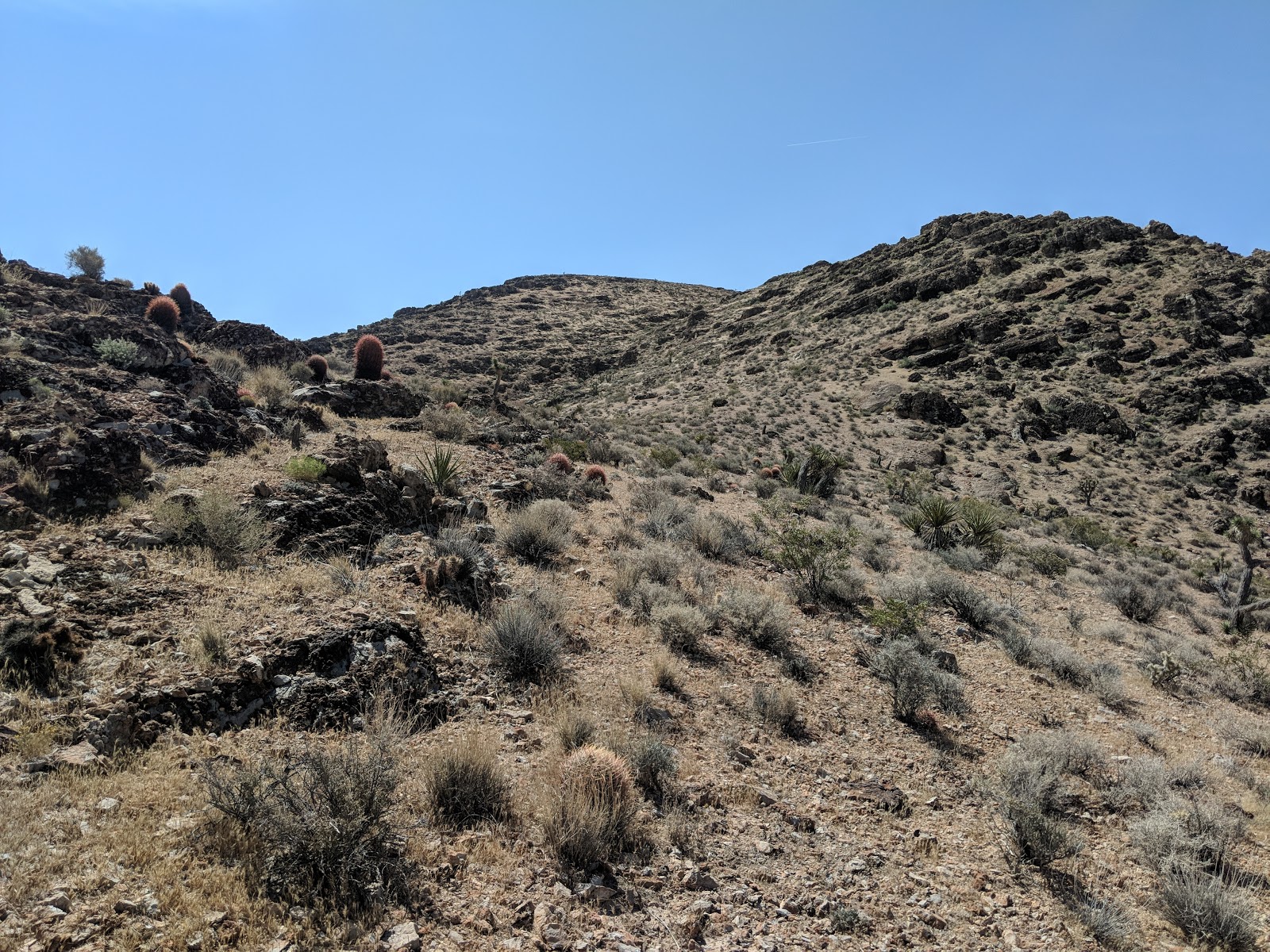
View of the summit.
There were great views of the area as I walked along the low ridge. I could see some of the ranches in the San Benito River valley. This part of the Diablo range has a very remote feel.
The reservoir was nearly empty. It was full when I was here in April.
The trail dropped into a small col, then started the climb up to the summit. At a flat area below the top the fire road branched. I took the right path, because it looked like less elevation change to get to the turnoff for the primitive trail that ran to the summit. This part of the trail was more overgrown than the road leading up to it.
At the trail junction at the flat area below the summit.
There was a small cairn marking the start of the primitive trail. The cairns marked the trail to the summit, with some old flagging tape. The route the trail takes is very different from the one marked on the map, but it is a better route. There were a few sections of this primitive trail that were hard to follow, but I made it to the open area near the summit without any problems.
The final section climbed up a dry stream bed.
The highest point is covered in very dense brush, so after tagging it I returned to the more open area to set up. I found a shady spot to sit, and went to set up my antenna. I had finished making a trapped EFHW antenna from QRPGuys, and it took some trial and error to find the best way to set up the new antenna. Once I got it in the air, the built in tuner was able to match it on the bands it was designed for, 20-30-40.
A somewhat pathetic setup. At least the yellow wire is easy to see.
I had no cell signal from where I was sitting, and RBN spotted me, so I had no desire to wander around looking for one. The chasers seemed weak, but I had no problem getting enough of them. I was able to work Rex, KE6MT, who was the first activator a few months ago, and who was kind enough to scare the rattlesnakes away. It made my hike more pleasant.
About to head down. Not totally dehydrated yet!
I decided to use the GPS and follow the marked trail on the way down. This was much more difficult than I anticipated. There really wasn't a trail, I just had to find ways through some of the dense, chaparral bushes. I made it back to the road in one piece, and retraced my steps back to the car. There was a lot more climb along the first ridge than I had thought, and it was much hotter now.
Black Mountain on the right, Pinnacles NP in the center distance.
Back at the car I drank the rest of my water, and cranked up the AC for the drive home. The car thermometer now read 100, and it felt like it.

Trailhead: Laguna Mountain Campground. At the top of the hill is the hiker parking.
Website: SOTA Site.
Maps: AA6XA SOTA Hikes map.
Red Tape: None. No fee to park!
I had a brief staring contest with a hummingbird. 

Tuesday, June 19, 2018

W7N/CK-228

This low peak is south of Las Vegas, very close to I-15. I used the trailhead and route described by others. I parked near the corner of Cameron St and Roark Ave near the Army Reserve Center, and followed the dirt road that continued off of Cameron.
First bend in the road. Army center with summit behind.
There are a number of dirt roads in the open area before you enter the canyon. There is no route through this area that is obviously better, so just head into the canyon. I had to detour a bit to stay outside of the Army's area. Once you enter the canyon there is only the road and train tracks.
Height of land in the canyon, shortly before the turn off.
A short distance past the height of land in the canyon there is a turn off for the access road that takes you to the summit. It continues up and away from the peak, then turns around in a switchback and heads towards the summit. The road is on the south side of the hill, overlooking the canyon you just walked up in. The road is well graded, and I made good time up to the summit.
Looking back at the switchback.
The road ends at the towers, but the high point is just beyond, outside of the fenced area. I climbed up the final few feet and found a place to set up. No good table-like rocks to sit on. I started on 17 meters and worked my way down the bands. Conditions were not great, but I didn't have to struggle for contacts. I was able to get a summit-to-summit with Jamie, N6JFD up in the Tahoe area on 40.
The view of Las Vegas from the summit.
Before I packed up I checked SotaWatch and saw that there were some activators in New Mexico, and was able to work them on 30 and 20 meters for two more S2S contacts. By this point I was getting hot, so I packed up and retraced my steps back to the car. As I was descending, still near the top, and train went by on the tracks. When I got back down to the road in the canyon, another train went by.
The second train goes by.
Back at the car I cranked up the AC and headed back to the hotel for a shower and some lunch.

Trailhead: I parked at the corner of Cameron St and Roark Ave
Website: SOTA Site.
Maps: AA6XA SOTA Hikes map.
Route: Follow the dirt roads into the canyon. Just past the height of land, take the tower access road up the hill to the summit.
Red Tape: Don't trespass on the army base. The route I took appears to be completely on BLM land, but there are lots of pockets of private land in the area.

Sunday, June 10, 2018

W7N/CK-177 Red Benchmark

This peak is right on the edge of the Red Rock Canyon area outside of Las Vegas. The best place to start seems to be at the Red Rock sign. There is a large pullout here where people like to stop and take pictures with the sign. I parked at the end of the pullout, then crossed the road. After a short road walk I turned up the hill. You could go up sooner, but there is a very steep embankment. If you cross the cattle guard, you have gone down the road too far.
A few feet up the hill. Cattle guard, with the red rock hills in the distance.
There are a few sub peak that you have to climb over or around on the way to the summit. The slope up to the first is a nice grade, with good footing. When I got near the top I could start to hear the shooting at the gun range on the other side of the hill. This was a constant annoyance the entire time.
Taking a breather on the way up.
After the first knob the ridge is fairly flat for a distance then starts going up again. There were some cliffs around the next knob, but they were easy to avoid by staying on the ridge. I did some side hill around the top of the sub-peak, and got to the col between Red BM and Pk 3853.
Looking at the peak, from the last col.
From here it looked like the easiest way up was to ascend the dry streambed. This took me directly to the summit plateau. I found the benchmark, then found a nice rock to sit on and got set up. It was the day of the VHF contest, but I was up early, so I started on HF. Someone on the Slack group had said that 17 was open, so I started there.
One of the cliffs on the summit.
I made a bunch of contacts, then went down to 20, then 40, where I made one each. By this point the contest had started, so I got out the HT and started calling on the FM calling frequencies. I was surprised how little activity there was. After two hours, I only made 11 VHF contacts. If I had been in the Bay Area I would have made many many more. Despite the dismal results on VHF, I made some more HF contacts when I got bored of yelling into the microphone.
Mt Potosi on the left. Mountain Springs BM is one of the peaks in there.
After about 2.5 hours on the summit I decided I had had enough, so I packed up and retraced my steps back to the car. It had gotten windy while I was on top, but not as much as when I was over near Hoover Dam. The footing was very good, not many areas of loose sand or gravel to slip on.

Trailhead: Pullout at the Red Rock sign.
Website: SOTA Site.
Maps: AA6XA SOTA Hikes map.
Route: Go cross country up the ridge.
Red Tape: Don't go down the wrong side of the mountain or you'll end up on private land or worse, a gun range.
Interesting rock on the way down.

Friday, June 8, 2018

W7N/CK-171 Red Rock Canyon Peak 4109

This peak is a relatively easy hike near the town of Blue Diamond, in the Red Rock Canyon area near Las Vegas. I parked in a paved pullout on Arroyo Road, before reaching any of the houses. From here I started following a wash up towards the peak. At the bottom of the slope, I went up.
A short distance up, looking down at the car.
There are a number of cliffs and steep bits, but it was easy to find a way up to the top. After I had ascended a few hundred feet I found a use trail that followed the edge of the cliff, I took the trail and it brought me right to the summit. There was lots of evidence of horses or burros.
Looking West towards Potosi Mountain and Mountain Springs BM.
On top I set up my mag loop and got on the air. Twenty meters was in really good shape, and I made nearly 20 contacts easily, including three summit-to-summits. Since 20 was so good I decided to try 17, and made another half dozen contacts, some much closer than I would have expected. I then spent some time calling on 30 and 40, but only made one on each.
Frenchman and Frenchman NW visible across Las Vegas through the haze.
I had been monitoring the SOTA-NA Slack group, and someone mentioned that 10 meters might be open, so I went up and made three contacts, including one to Texas. I could have made one more, but the person was sending with a big swing and no space between characters, and I couldn't figure out his callsign.
Sloan Canyon area. Rattlesnake Mtn, Black Mtn, McCullough Wilderness HP, Sutor BM, Pk 3970.
I finished up on 15, getting one final contact. By this point my radio was getting very hot and I was getting hungry, so I decided to head back down. Instead of going cross country, like I had on the way up, I followed the trail that went along the edge of the cliffs. This was a slightly longer route, but it was easy to follow and descend. There were a few points where it looked like it would end in a cliff, but someone had found ways around.
Following the wash at the bottom.
At the bottom of the hill the trail crosses a wash, but I turned and followed the wash back to near my car. I had to do a little more cross country, but I managed to pop out of the brush at the pullout where I had parked. I saw a lot of use trails near the bottom of the mountain, and some of them may be good routes up the mountain. Have fun exploring!

Trailhead: Paved pullout on Arroyo Road, near Blue Diamond.
Website: SOTA Site.
Maps: AA6XA SOTA Hikes map.
Route: Go cross country up to the summit, or try and find a use trail that takes you there.
Red Tape: None.
Looking to the colorful Red Rock cliffs. The slope on the right goes up to Blue Diamond Hill.

Thursday, June 7, 2018

W7N/CK-182 Frenchman Mountain North West

I activated this peak on my way down from Frenchman Mountain. From the parking area, take the road up to the top of the second climb. From here you will have to go cross country up to the summit.
Face of the mountain from the col.
On the way up I angled up, following a faint use trail. After gaining a bit of elevation I went straight up to the flat area on the summit ridge. In this flat area I found a cairn and a more heavily used use trail. I followed the use trail along the ridge up to the summit.
Almost at the summit.
There are a few knife-edge like sections leading up to the summit, but nothing terrible. The climb up to the flat area is a class 2/3, depending on your route. On the summit I set up under the tripod and got on the air. The conditions were bad on Frenchman Mountain, and they were even worse up here. I struggled to get my four contacts. I managed one on 40, none on 30, and then got W0MNA and W0ERI on 20. After changing frequencies to avoid a QSO, I finally got two more. There was really deep QSB, and no propagation.
Looking over to Lake Mead.
After I got the last contact I packed up and headed down, glad that I had gotten the points for the summit. I followed the herd path back to the flat area on the ridge, then noticed the cairn was marking a different path down. I decided to take this path, which descended directly to the col with a lot of small switchbacks. It was still steep, but probably better than the way I had gone up. I would recommend this route for up and down.
Some encouragement on the way up.
The road was still steep, but I made good time back to the trailhead and car, passing someone else who was on his way up.

Trailhead: Pullout off of NV 147, at the base of the access road.
Website: SOTA Site.
Maps: AA6XA SOTA Hikes map.
Route: Take the road to the col at the top of the second climb. Go up the ridge to the summit, following faint use trails.
Red Tape: None.
Canyon at the bottom of the second climb.

W7N/CK-175 Frenchman Mountain

This mountain has a number of towers on the top, so there is an access road that goes to the summit. The trailhead is at the height of land on NV 147, to the east of the city. There is a large dirt lot, with plenty of space to park.
Looking up at the first climb.
There are three climbs to get to the summit. The first one is not so bad, a bit steep. At the top is a relatively flat section is a canyon, then a steep climb with some switchbacks to the Frenchman NW col. The trail is an access road for the summit, but it is the steepest road I can remember being on. It would take a high clearance vehicle with some extra low gears to make it to the top.
Top of the first climb, looking at the second.
At the top of the second climb I caught up to two guys who weren't going any farther. They seemed impressed that I had gotten up so quickly, and that I was continuing on to the summit. After a quick drink of water I set off down into the key col. This descent wasn't as steep as the ascents I had done so far.
In the deep col, contemplating my life choices.
This last climb was steep. If the top of the mountain was a little less steep, they probably wouldn't have put in any switchbacks. It was hot, but I did make it to the top. The towers are fenced off, so I found a flat slab of concrete to sit on and got set up. The conditions were terrible, and I only made seven contacts. There must have been something in the concrete too, because I had trouble getting a good match on the mag loop.
End of the road.
I didn't even try VHF, I assumed there would be too much RF from all the towers to make it fun. Once I was done I packed up and headed down. The road was slick in places where there was a lot of sand, but I made it down to the key col without falling. I climbed back up to the top of the second climb, and turned off to get Frenchman Mountain NW.

Trailhead: Pullout off of NV 147, at the base of the access road.
Website: SOTA Site.
Maps: AA6XA SOTA Hikes map.
Route: Take the road to the summit.
Red Tape: None.
Contemplating the ridge hike to the next summit.

Wednesday, June 6, 2018

W7N/CK-186 Rattlesnake Mountain

Surprisingly, this peak had not been activated before, despite it not being a challenging hike. I parked at the McCullough Trailhead, off of McCullough Hills Parkway in Henderson. There was plenty of parking, but sadly none of the shady spots were open. This is another trail that starts with a paved section, in this case a bunch of switchbacks. The switchbacks aren't really necessary unless you're handicapped.
Starting up the hill.
At the top of the low hill the trail intersects a rough dirt road that runs along the power lines. Turn left here and start following the McCullough Hills Trail. There are large metal markers at intersections, and the trail was well worn. After following the power lines for a while the trail turns to the left and stays fairly level for a mile or two.
One of the trail markers.
At the top of the wash that the trail has slowly been descending into, it crosses, then goes up a few switchbacks to a small shelter. A few mountain bikers passed me here, and I saw lots more tracks in the dirt. I took a few minutes rest in the shade before the real climb started.
McCullough Trail Shelter. Too bad the benches weren't in the shade yet :(
The shelter is where I left the trail and started going cross country up to the summit. I went straight up the ridge by the shelter. The slope was pleasant, and there were not steep parts or areas with bad footing. I made good time up, despite the heat.
Setup, with Black Mountain in the background.
I started on 20 meters, and got a number of the usual chasers. As I was finishing up on the band, I got word that a conference call for work was about to start, so I called in. After finishing the call, I tried 30 meters, but didn't get any responses. Forty came back with more chasers. There was a lot of RF in the 2 meter range, so I made one contact on 440. I was getting hot, so I packed up and headed back down, retracing my steps.
Back at the power lines.

Trailhead: McCullough Trailhead, Sloan Canyon Conservation Area.
Website: SOTA Site.
Maps: AA6XA SOTA Hikes map.
Route: Take the McCullough Hills Trail to the shelter. Take the ridge up to the top.
Red Tape: None.