Thursday, June 30, 2022

W6/CT-037 Cahuenga Peak


 My trip to southern California was coming to an end, but I had time for one more peak before going to the airport. I chose Cahuenga Peak, probably best know for the Hollywood sign on it's side. I, however, did not go to the famous sign.

Views on the way up.

I hiked in from the west, parking on Lake Hollywood Drive, just past (south of) the intersection with Wonder View Drive. This seems to be the official parking for recreation in this area, with parking allowed on both sides of the street all the way down the hill. Since it was a weekday, I was able to park fairly close to the top. The first part of this hike is a walk up Wonder View Drive. At the end of the houses there is a fence, with a gate to allow pedestrian access.  Just past the water tank, the trail turns off the fire road and starts to climb.
Well signed trails.

This area seemed to be part of Griffith Park, and was very well signed. I took the Burbank Peak Trail up to the ridge. The trail was much rougher than I was expecting for a park so close to LA. It is basically a giant switchback up to the ridge. On the ridge, I made a short detour to Burbank Peak and the Tree of Life. Its a tree, and I still haven't figured out why it has that name. Once I was satisfied with the tree, I went up the Aileen Getty Ridge Trail to the summit. There is not a lot of space on the summit, but I found an out of the way place to put up my end fed.
Set up on the summit.

The cell service was not very good compared to what I was expecting. Its possible I was just in a bad spot though. I made contacts on 17m, 20m, and 40m. I thought I might get a lot of people on VHF, so I was disappointed to only get five QSOs on 2m. It was warm in the sun, and I had a plane to catch, so I didn't spend too long hanging out on top. On the way down a family stopped to ask for directions. It amazes me how many people will go out hiking with no idea what they're getting into. 

Trailhead: Lake Hollywood Drive, near Wonder View Drive.
Website: SOTA Site.
Maps: AA6XA SOTA Hikes map.
Route: Walk up to the top of Wonder View Drive. Go through the gate, then up the Burbank Peak Trail to the ridge. Follow the trail to the summit.
Red Tape: None. Make sure to obey the "No Parking" signs. 
Video: ham_bitious YouTube

Tuesday, June 28, 2022

W6/CT-247 Mt Williamson


 Immediately after hiking Mt Islip I hiked up Williamson. Since I was already parked at Islip Saddle, I stayed there. The first part of this hike is up the PCT. There were a number of thru hikers heading up, and I was surprised I was able to catch some. I guess only having a small daypack really makes it easy to hike faster.

Flowers were still blooming.

The PCT section of trail is a few giant switchbacks up to the ridge. This area had also burned in the Bobcat fire, but looked like it was starting to recover. It was around noon, and was getting quite warm. The sections through trees were welcome. On the ridge, the PCT starts down the other side, but I turned right and followed the trail up. From below, it looks like the trail leads to the summit, but it only goes to the southeast peak, which is a bit lower. It may be in the activation zone, though. I tagged it, then headed for the high point.
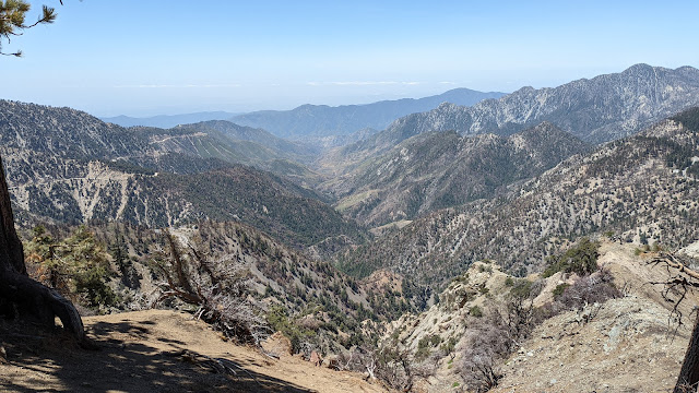
Excellent views down the canyon.

The trail from the southeast peak was much rougher than the hike up. As I hiked over, a glider started flying back and forth over the ridge. It looked like it was gaining height on each pass. Over on the summit I found the remnants of a register. There was one very green plant amidst the burned trees. My suspicious was confirmed when my phone was able to identify it as Poodle Dog Bush. Scary! I watched my step as I set up. 
Burned zone on the way down.

I didn't have any cell service on top. Twenty and 30m didn't seem to be very good, but I got a nice pileup on 40m. I then tried VHF again, and was rewarded with contacts on both 2m and 70cm, including two summit to summit contacts. It was getting hot in the sun, so I packed up and headed back. There were more thru hikers still heading north, and a few day hikers as well. Back at the car I cranked the A/C for the fun drive back down to the hotel. 

Trailhead: Islip Saddle, Angeles Crest Highway.
Website: SOTA Site.
Maps: AA6XA SOTA Hikes map.
Route: Take the PCT north to the ridge, then take the trail to the summit.
Red Tape: None. 
Video: ham_bitious YouTube

W6/CT-010 Mt Islip


 It was forecast to be a beautiful day, so I headed up to the Angeles Crest Highway to do some hiking. On the schedule were Mt Islip and Mt Williamson. The highway was close at Islip saddle, so that was the trailhead I used. The lot was nearly full when I got there, from backpackers as I soon found out.

The route up follows the PCT to the campground.

Once I found the trailhead across the street, I started up. There are a few switchbacks to get up the steep embankment, then a pleasant walk through the forest. There were a lot of people coming the other way. About half of them were thru hikers, and the other half looked like they had just spent the night at the Little Jimmy campground.
Burn zone.

The trail crosses through some burn zones from the Bobcat fire. It was interesting to see where it had burned, then seemingly stopped randomly. I did have to appreciate all the work done to reopen the trail. Passing through the campground, I was amused at the antics of all the scout troops. Reminded me of backpacking trips with my troop. After the campground, the real climb starts. It was well graded, but definitely going up.
Overcast in LA.

As I climbed up to the ridge, the views got much better. I also stopped passing people, and it felt like the mountain was mine. Just below the summit is the remnants of a small building. The roof is long gone, as well as the doors and windows, but it would have been a neat little cabin. 
I set up on the LA side of the summit, so I could enjoy the view while operating. There was enough brush to easily put up the antenna. I didn't have cell service, so I decided to only do 20m/30m/40m, since 17m hadn't seemed that great the previous week. This worked out well, and I got lots of contacts.
Former summit hut.

Since I had a good view of the LA area, I decided to try some VHF. I soon had a small pileup on two meters. Southern California seems to be a great place for VHF. As I was packing up other hikers started arriving at the summit. I guess the hike is more popular than I first thought. On the way down I passed a bunch of people taking pictures along the ridge. The campground was empty when I passed through again. Back at the parking lot there was some trail magic for the thru hikers. I simply crossed the lot and headed north on the PCT towards Williamson.

Trailhead: Islip Saddle, Angeles Crest Highway.
Website: SOTA Site.
Maps: AA6XA SOTA Hikes map.
Route: Take the PCT south to the Little Jimmy Campground, then turn right and take the trail to the summit.
Red Tape: None. 
Video: ham_bitious YouTube

Monday, June 27, 2022

W6/CT-067 Table Mountain


 After hiking Circle Mountain I drove up the Angeles Crest Highway a few miles to Table Mountain Road. Here, I drove up to the end, where there is a big parking lot for Mountain High North Resort. There were a few cars there, and the restaurant seemed to be open. I tried to get a shady spot.

Abandoned ski lifts.

From here it was a short walk up the hill to the top of Table Mountain. There is an active disc golf course here, so be careful. After walking around a little, I found a tree that I could sit behind that looked like it would offer protection from wayward discs. And as a bonus, it was shady.
My protector tree.

I used a downed tree to hold up my antenna, strung up away from the golf course. I had very marginal cell service, and I wasn't able to reliably get out spots. Despite this, I made plenty of HF contacts, and some summit-to-summit stations even found me. It was pleasantly cool on top, a nice change from the two exposed summits I had just done.
View down to the desert.

Once I was done, I walked back down to the car for the long drive back to Palmdale. It was sad seeing the burned joshua trees down in the desert from the Bobcat fire. Those trees are really neat. 

Trailhead: End of Table Mountain Road (4N21).
Website: SOTA Site.
Maps: AA6XA SOTA Hikes map.
Route: Walk up and find a good spot. The parking lot appears to be just below the AZ. 
Red Tape: None. 
Video: ham_bitious YouTube

W6/CT-071 Circle Mountain


 After getting back to the car from Ralston Peak, I continued driving up Lone Pine Canyon Road to the height of land, just south of Wrightwood. Here I parked in a small pullout by a gate and started up to Circle Mountain.

Parking spot behind the camera.

The trail starts as a fire road, and drops a short distance to a col. Here I passed some guys taking their dogs for a walk. When I told them I was going to the summit, they seemed impressed, saying they'd never been. The fire road ends here, and it becomes a single track trail.
High peaks of the San Gabriel Mountains.

The trail obviously sees maintenance, there were plenty of trimmed branches and such along the way. It wasn't too steep, especially compared to what I had just done on Ralston. The summit is fairly large and flat, but I found a small cairn with a register. After checking for red ants, I stopped and signed it, then put up the antenna. 
On the air with my QCXmini.

The cell service was marginal, and combined with the hot sun, my phone got hot enough to turn itself off. However, I had no problems getting contacts on the bands, making at least one on each band. As I was packing up I noticed some structure farther down the summit. It could have been a picnic table, but I didn't want to walk over to find out, so I just went down. 
Nearly back at the road.

It was a quick trip down. Back at the car I blasted the AC and drove up a bit farther to get Table Mountain.

Trailhead: Height of land, Lone Pine Canyon Road.
Website: SOTA Site.
Maps: AA6XA SOTA Hikes map.
Route: Follow the road then trail to the summit. 
Red Tape: None. 
Video: ham_bitious YouTube

W6/CT-134 Ralston Peak


 This was the first peak of a three peak day in the Wrightwood area. I parked in a small pullout on Lone Pine Canyon Road at approximately (34.3057, -117.5079). There are a few places in this area that are viable for parking. 

Looking back at the parking spot.

I crossed the road and started heading through the low brush towards the summit. There is a depression that you have to cross. I tried to go around the side, but it seemed to be more effort than it was worth. As I approached the mountain I tried to decide which of the ridges to go up. They all looked steep and unpleasant, so I just picked the right one. I'm not sure if this was a good choice or not.

Looking at the summit from near the road.

As I expected, it was very steep, made even more fun by the loose dirt and rocks. I was glad to get to the relatively flat section on top. Thankfully, the brush was sparse enough that it was easy to go cross country up the hill. On top, I made my way over to the summit. I found a register under some rocks, and signed it. However, as I was signing, some red ants crawled up my legs and started to bite me. It was quite painful.

Looking over at Mt Baldy.

Despite the ants, I managed to find a spot to sit and have a nice activation. There was good cell service. The views were excellent, and there was a pleasant cool breeze blowing in from the ocean. On the bands, I managed to work Indonesia again. Once I was done I packed up and retraced my steps. Going down was not as difficult as I feared it might be, and I managed to get down safely. Back at the car I drove further up the road to the Circle Mountain trailhead. 

Trailhead: Lone Pine Canyon Road, west of the summit.
Website: SOTA Site.
Maps: AA6XA SOTA Hikes map.
Route: Cross country up to the top. 
Red Tape: None. 
Video: ham_bitious YouTube

Wednesday, June 1, 2022

W6/CT-273 Agua Dulce Benchmark

 I had a Friday off, so that meant getting a new SOTA peak. I had this peak on my radar for a while, and decided to just go do it. Based on some other trip reports, I thought I could follow a dirt road up from near where Agua Dulce Canyon Road crosses CA 14. I parked in a large pullout, and headed down. 

Gate near the start of the route.

The road crosses a dry stream bed, then starts to climb. However, at the start of the climb was a locked gate with a clear "no trespassing" sign. Since there was an official looking truck parked in the pullout, I decided to use my second route. I went back to the car and drove a few miles down the road to a large pullout near a telephone pole.

Second trailhead. Not nearly as bad as Burn Benchmark.

I parked and took a look around. There were no fences or signs, so I started up the hill. I found a faint use path that went up to around the power lines, then ended. However, it was simple and steep to just follow the ridge up to the summit.

Summit area.

The left side of the ridge was very steep, almost a cliff, and the right side only a bit less so. It felt like a knifes edge at points, but was wide enough not to be scary. Eventually I made it up to the summit, probably sooner than I would have if I had started up near CA 14. The route was less than a mile.

San Gabriel mountains in the distance.

I used an old post to hold up my pole, and got on the air. I was close enough to the freeway to have good cell service and hear all the cars. Since it was Friday, there were a number of other operators out, and I got a bunch of summit to summit contacts. 

I took the same route down, double checking to make sure I took the correct ridge. It would've been a pain if I had to backtrack up one of the steep slopes.

Trailhead: Agua Dulce Canyon Road, about (34.43925, -118.3333)
Website: SOTA Site.
Maps: AA6XA SOTA Hikes map.
Route: Follow the ridge to the summit.
Red Tape: None. 
Video: ham_bitious YouTube

W6/CT-130 Grass Mountain

 Immediately after activating Burn Benchmark, I crossed San Francisquito Road and drove up the dirt road on the north side to Grass Mountain. This is road 6N04. It was a bit rough, but the sedan I had was able to make it without scraping, bottom or sides. About two thirds of the way up, there is a junction, where you continue straight (left) onto 6N05. This road crosses the PCT, then ends at the summit.

Antenna set up in the grass on Grass Mountain.

There is a large turn around area, and I parked on the side. There was no one else up there, and I didn't expect to see anyone. Since it was close to noon and getting hot out, I found a place under some of the trees to set up. I missed out on a view, but was much more comfortable.

MTR 3B making contacts.

There were a lot of flies on the summit, which made operating no fun. I had enough cell service to spot. Because of the flies, I did not spend a long time on the bands. I made four contacts on 20m and three on 40m, then decided I had had enough. I threw everything back in the car, and got out of there. After a bumpy ride down, I made it to the pavement and back to civilization. 

Trailhead: End of 6N05. Multiple options if you want to hike up.
Website: SOTA Site.
Maps: AA6XA SOTA Hikes map.
Route: Drive up to the top!
Red Tape: None. 
Video: ham_bitious YouTube

W6/CT-136 Burn Benchmark

 A new day, a new Burn Benchmark. The previous day I had activated the other one, and now it was time to complete the set. I drove to height of land on San Francisquito Canyon Road, where the Leona Divide road crosses. On the south side of the road there is space for a few cars to park, so I did.

Town of Green Valley.

My planned route was to take the fire road as close as I could, then find a way up to the high point. There was a big rut near the start of the road, so I decided to just walk, since I only had a sedan. As it turns out, the road was in excellent condition, and I probably could have driven.

Transverse ranges wilderness.

Either way, it was a nice morning for a walk, so I set off up the road. The sun was low enough the hills provided some shade, which was welcome. Part way up I saw a snake sunning itself on the side of the road. We looked at each other as I passed.

The fire road doesn't go over the summit. When I got close, I started looking for places to go up to the top. I found a section clear of brush, and hopped over a fence to follow it up. I was surprised to find an OHV trail running along the ridge top. My guess is that I could have found a way up that avoided the bushwhacking.

Setup on the summit.

There was a register under a pile of rocks, which I signed before setting up. I had good cell service. I did 17m, 20m, and 40m. I tried VHF, but there wasn't anyone there. The views down into the Antelope Valley were quite nice, if a bit hazy. Once I was done, I packed up and retraced my steps. It had warmed noticeably, and I was glad to be going down. Back at the car I crossed the road and drove up to Grass Mountain for a second summit.

Trailhead: Junction of Leona Divide Fire Road and San Francisquito Canyon Road
Website: SOTA Site.
Maps: AA6XA SOTA Hikes map.
Route: Walk or drive up the road to near the summit, then find an opening in the brush up to the top.
Red Tape: None. 
Video: ham_bitious YouTube