Tuesday, December 15, 2020

St Joseph's Hill

 St Joseph's Hill is an easy hike to a nice viewpoint in the south bay. We parked near the boat launch for Lexington Reservoir, and headed up the trail. The first section is steep, but partially paved. The trail the levels out, before climbing more after the next junction.

View to the north.

There is a small network of trails around the summit. It was the day after Thanksgiving, so the trails were pretty busy. We got to the summit right as another group was leaving, and grabbed the bench to have lunch. 
Lexington Reservoir.

We continued around the south side of the hill to go down. There were great views of the reservoir and Highway 17. The hike down was quick, and seemed less busy than the route up. 
Forest near the start.

Friday, December 11, 2020

Vollmer Peak, Grizzly Peak, Wildcat Peak

For my run, I decided to go up to Tilden park to get some more peaks off the Nifty Ninety list, Vollmer Peak, Grizzly Peak, and Wildcat Peak. I started at the Meadows Picnic Area, just off of Central Park Drive. 
Heading up the trail on a beautiful day.

I took the fire road trail up towards the main ridge. It was a gorgeous day, and the trails were rather busy. The walk along the ridge was awesome, as you'd expect. SF was clearly visible across the bay, and Diablo on the other side. 
SF, Golden Gate, Mt Tam.

I had been to Vollmer Peak before, but I went up to the top anyways to play radio for a while. I made contacts on 20m and 40m, but there was some interference on 30m from the towers up there. After making a few final ones on 2m, I packed up and headed down and over towards Grizzly Peak.
Grizzly Peak summit. Not that impressive.

The parking area at the end of the tower access road was closed to parking, and there weren't many people in the area. I walked up the road to the summit, taking a few pictures before turning around for the long descent back towards the car. 
Wildcat Creek, a short distance below Lake Anza.

It was a nice trip down to the starting area, then over towards Wildcat Peak. There were enough switchbacks on the climb that it wasn't too difficult, but I did start seeing more and more people. 
View to the north east from the summit.

Wildcat Peak was very crowded. I stopped long enough to enjoy the view and refill my water before continuing along the ridge. This section was much less busy, and the views were just as nice. 
Sunset over SF and Marin.

It was a nice ridge run, then a steep descent back to Wildcat Creek. The return to the car wasn't as bad as I feared. I was much more tired a year or two ago when I did a similar loop during an orienteering event. I must be getting in better shape. 
Eucalyptus grove.

Overall a great day for a loop in a nice park. 

Tuesday, December 8, 2020

W6/SC-077 Joaquin Ridge

 After a full day of OHV driving and peakbagging, we woke up at our campsite near Wright Mountain. It was warmer than we were expecting, but no one complained. After a quick breakfast we continued our drive down the road to the end to get Joaquin Ridge. 

Sunrise over Coalinga.

There is a parking area and picnic table at the end. It would make a nice place for camping. The gate is locked and no vehicles allowed, but the road had obviously been graded recently. It was a pleasant walk in the early morning sun.
End of the road.

The road drops down to a col, then climbs up towards the peak. A short distance below it, it turns right and goes across the face, below the cliffs. We took the road to the place where it started to turn. 
High point is the top of the cliff.

Here we stepped off the road and immediately found a use trail running up the ridge. Since it was going in the right direction we decided to follow it. Only the last hundred vertical feet or so are covered in dense brush and vegetation, so even if it hadn't been there it would have been easy to get up most of the way. 
Off trail, admiring the summit.

Lucky for us, however, the trail continued into the brush and all the way to the summit. There were a few switchbacks on the climb in the trees. Parts of it seemed like it was an abandoned trail.
Almost there. 

There is a large clearing just below the high point. We stopped here to set up the antenna. I went first on 20m. I had to go way up the band, nearly to the phone portion because of the contest traffic. Eventually I found a clear spot and started calling CQ. It was a constant battle keeping my frequency from the contesters. 
First outing for my FT-817 and MX-P50m.

Once I had gotten everyone, Rex sat down to use it. While he was operating I went over to the high point to see if I could get anyone on VHF. I didn't, but the views were excellent. 
Looking down at the operating clearing. 

Rex had a deadline to be out of there by, so we didn't linger on the summit. We retraced our route back to the car, and started driving out. We decided we had enough time for a quick activation of Santa Rita Peak on the way out, so we ran up for a quick one. Luckily, crazy motorcycle guy didn't show up.
The Diablo range is beautiful.

The drive out was not as difficult as the way in, although we did make a wrong turn at the bottom of the hill. Back at the campground we pumped up the tires and started the long drive back to San Jose.

Trailhead: End of the road, past Wright Mountain.
Website: SOTA Site.
Maps: AA6XA SOTA Hikes map.
Route: Follow the road to where it turns below the summit, then bushwhack up the rest of the way.
Red Tape: Each person needs a day use permit to enter the ACEC zone, and each vehicle needs a separate permit to drive into the trail system (and get the gate code).

W6/SC-055 Picachos High Point

 This peak is deep in the Clear Creek Management Area, a large section of BLM land. Access is fairly restricted due to naturally occurring asbestos in the serpentine rock in the area. It had been a few years since my last visit with Rex, KE6MT, and I managed to talk him into taking me for another trip. This time we decided to spend two days, and camp down there. 

Looking back at Laguna Mountain from the fee station as we aired down the tires.

At the wide area at the fee station we aired down the tires for a smoother ride then started the real driving. Clear Creek road was in decent shape, but as soon as we turned onto R5 it got much rougher. Rex did an excellent job getting up the road. 
Time for some car surgery. 

About half way up we stopped to check the car and make sure it was still ok. After a quick walk around, it was discovered that a plastic panel on the bottom had started coming off. We had to pull it off the rest of the way so it wouldn't drag. This done, the rest of the drive up to the Picachos High Point was uneventful. 
On the way up to the summit.

The road goes through the activation zone, and we parked at a wide spot by a clearing below the summit. It was a very short distance to the actual high point, so we both bushwhacked up to it to take a few pictures and sign the log. There were not many entries in it. 
On the summit.

We then returned to the road side clearing and set up the linked dipole and got on the air. Despite the contest going on we were able to find clear spots on 40 and 20 to make some contacts. It was easy getting them, since we were running 100w.
Antenna on the summit.

Once we had worked our pileups we packed up and continued across the ridge to San Benito Mountain for a quick activation as the sun set. I was able to get New Zealand and two Japanese stations. With the last bit of light we packed up and drove down the road to get out of the Serpentine ACEC zone to camp for the night.
Camping near Wright Mountain.

It was a clear night with a full moon, and we watched the stars and moon while cooking dinner and before going to bed. 

Trailhead: R5, just below the summit.
Website: SOTA Site.
Maps: AA6XA SOTA Hikes map.
Route: Bushwhack up to the summit.
Red Tape: Each person needs a day use permit to enter the ACEC zone, and each vehicle needs a separate permit to drive into the trail system (and get the gate code).

Wednesday, December 2, 2020

W6/NC-340 Tulucay Benchmark

 It was Thanksgiving, and with no family in the area it meant it was time for a hike. This time I decided to go up to Napa and do Sugarloaf Mountain and Tulucay Benchmark. I left early, and got up to Skyline Wilderness Park by 8. It was chilly, since the sun hadn't risen over the ridge yet.

Near the start of the trail, scaring away the turkeys.

I took the most direct way up. The trail starts easy, going over to the advanced disc golf course. At the course it starts climbing, but never at a bad grade. 
First viewpoint, looking north along Napa Valley.

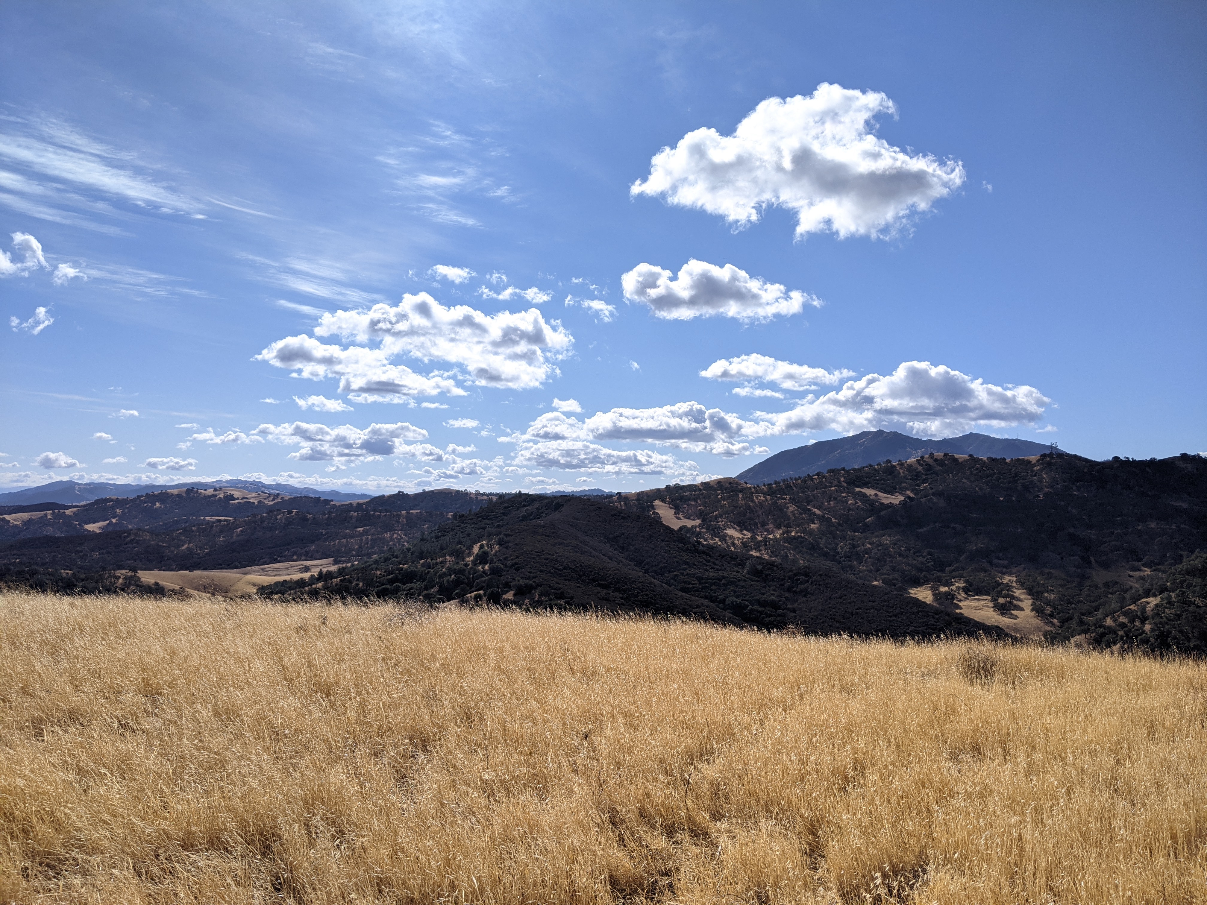
There are a few viewpoints on this lower section, and all the peaks along Napa Valley were visible. It was a beautiful and clear day. The trail I took then goes into the stream's canyon for a while. It was steep but a good hiking trail. At the other end of the canyon I came out and started the real climb.
The trails are well marked.

As you climb, the views get better. Closer to the top I could see Mt Tam across San Pablo Bay. I had to stop on the way up to watch some deer just below me in a field.
Two of the deer.

The summit isn't very interesting. It is in the forest without any views. I stopped for a drink, then started over to the higher benchmark. The descent down to the col is easy, in open forest. There is an unmarked fence at the low point. It was easy to cross since the top strand was not barbed.
Burned manzanitas.

The climb up the other side was more interesting. There were some sections with lots of burned bushes to pick through. Luckily the density was fairly low and it was not difficult. A little higher up the bushes end and it is just low brush and rocks.
Almost at the summit.

I stopped a little below the summit to set up the radio. I had good cell service on top, and had no problem spotting or getting contacts. I was hoping for some good DX, but I didn't get much. As I was sitting I noticed an open spot on the ridge south of the towers. That might be a better place to setup and operate from. 
The benchmark itself.

After I was done on the radio I went up to the high point to tag it before retracing my steps down to the col and back up to Sugarloaf peak. Since I wasn't in a rush, I took the long way down, continuing across the summit the way I came. 
View back up to the peak.

The views descending were excellent, lots of open areas. In a few years, if more brush grows back, a better route to the benchmark might be from this area. The south side of the hills were open grass, and you'd just have to cross the gully separating them from the trail area.
Reservoir through the trees.

At the base of the peak there is a dam with a small reservoir. I hiked along the the west side, then up along some of the ridges west of the peak. It was a gorgeous day and I was in no hurry to get back. The views from some of the ridges were great. The park seems to be popular with mountain bikers, and I was passed by quite a few of them. 
Vineyards at the southern end of the valley.

The trail ends at the RV campground section of the park, and I had to cross it as well as part of the disc golf course to get back to the car. It seems like the course wasn't designed very well, since a tee was on the opposite side of the path from the hole, and some golfers had to wait for me to go by. Overall, this was an excellent hike to a nice peak. Would recommend. 

Trailhead: Skyline Wilderness Park, Imola Ave.
Website: SOTA Site.
Maps: AA6XA SOTA Hikes map.
Route: Pick your route to the top of Sugarloaf, then bushwhack across the col to the summit.
Red Tape: None.

Tuesday, November 17, 2020

Rose Hill

 Black Diamond Mines Park preserves some ghost towns from when the area was the biggest coal mining area in California. In non-Covid times, you can go on tours of the mines and such, but since everything was closed, I just went for a run. 

Overcast views.

It was overcast and chilly when the gate finally was opened and I parked in the main lot. There were a lot of people unloading bikes, and I saw lots of mountain bikers while out. I started up the hill to the east, beginning a big loop around the park.

On one ridge. 

Despite all the people I saw in the parking lots, the trails were fairly empty once you got away from the roads. It had been a few years since I had been to the park, and it was much nicer than I remember. Gorgeous open ridges with great views in all directions. Just awesome.
Imagine the spring, with green grass and wildflowers.

My first destination was Peak 919, a P300 peak in the park. 
No longer overcast!

On the way I passed by the group campsite, then Star Mine. The entrance is gated shut, but you can look down the entry shaft. I can't imagine walking down it every day for work. 
Star Mine entrance.

After going by Star mine, I started climbing up towards the top of 919. This is also the first section that was in the trees. The high point is a little distance off the trail, but it isn't a hard bushwhack. 
Back down in the valley. A very nice valley.

The top is rocky, and you can just about get above the bushes for a view. I decided to go down the west face of the hill, since that was the direction I wanted to go eventually. This was a mistake. It was super steep, and there were some short class 3 moves to get down. I would just backtrack to the trail next time.
Oak hills of the east bay.

Back on the trail I continued into a wide, gentle valley. This is one of the prettiest areas of the park, I think. On the north side there is a sign pointing out the tailings from one of the old mines. I took the trail that goes up and over the tailing pile, then climbed the rest of the way up to the ridge.
The tailings of one of the coal mines.

It was fun to be able to hike up the hill faster than the mountain bikers. Normally runners can't keep up. Up on the ridge I wound my way around to the pass above Nortonville. Here I crossed the trail, and took the use trail up the steep slope to the top of Rose Hill.
Nortonville cemetery.

The views from Rose Hill were superb. It is the highest point in the park, and it feels like you can see everything. As I was enjoying the hill, I heard some rustling in the grass. When I looked over, I saw a cat head pop up. This scared me, since I didn't know what kind of cat it was. We looked at each other, than the cat turned and walked away. I could see the small tail and knew then it was a bobcat. I might not be here writing if it had been a mountain lion.
Mount Diablo and North Peak.

After my cat encounter I decided not to hang around, and headed down the other side of the peak, back to the trail. I passed some cows, then made my way back to the car. It had been an excellent outing, and I would recommend the park to anyone, just not in the summer. 

Monday, November 16, 2020

Round Top

 It turns out there's an old volcano in the bay area, and its in a park. Sibley Volcanic Regional Park is just south of highway 24 at the crest of the Oakland Hills. The parking lot isn't super big, but it seems there is plenty of street parking.

Heading up.

Getting to the summit is pretty easy. You can either walk up the access road, or take a trail up about half way, then the road the rest. We opted for the trail approach. It was a gorgeous day, and really nice to be walking in the woods.
Not really any views on the summit.

The road is paved, an not too steep. Its an easy walk up to the top. The summit is covered in towers and surrounded by trees, so not very good views. After walking around a little on top, we headed back down to do a loop through more of the park. There are interpretative signs near interesting rocks explaining how the geology works.
Through some small hills. Felt like I was in a Western.

The views were excellent, but highway 24 was a constant sonic reminder that we weren't in the wilderness. We went around, then dropped into the canyon. The climb out was pleasant. We had hoped to have a picnic at the trailhead, but all the tables were closed. So we sat on the ground for lunch instead, and watched the horses come, then go.
Heading back up to the trailhead.


Thursday, November 12, 2020

Redwood Peak

 Redwood Regional Park is a park in Oakland that I had never been to before. The high point, Redwood Peak, is on the Nifty Ninety list, so I knew I'd go eventually. I decided to do a long run through the park and over the summit.

Serpentine prairie at the start.

I started at the Trudeau Center on Skyline Blvd. The interpretative signs here indicate the area is probably what the Bay Area looked like before Europeans arrived with their non-native plants. I took a long route through the park to the summit. 
Some of the redwoods.

It was pretty chilly in the canyons and warm on the ridges. I think there was a thermal inversion. The big canyon along Redwood Creek was quite cool. The park was much nicer than I was expecting. I thought it would be similar to Tilden, but it was much more forested and felt more wild. 
Round Top through the trees. Tomorrow's destination.

Eventually I wound my way around and up to the summit. The high point is above an archery range, but the fence is well signed to keep you out of the firing area. The summit was rocky, with lots of graffiti scratched into the rocks. Such a pity that people feel the need to do that. 
Redwood Peak summit.

On the way down there was an excellent viewpoint. A bit hazy, but a nice view.
Bay area hills.