Friday, September 21, 2018

W6/CV-017

After coming down from Mt Vaca I drove over to Pena Adobe Regional Park to get this summit. There seemed to be some sort of event going on, so I parked in the dirt lot near the bike trail. I didn't see any signs or places to pay, so I didn't.
Parking area from the trail.

I set off down the trail, which follows the road over to Lagoon Valley Park. I wasn't watching the map closely, so I missed a turn off. When I noticed, I decided to just take the scenic, roundabout route to the top.

Typical view in the park.

I climbed up a steep hill, then took the trail that followed the park boundary. Eventually it met up with the wide gravel road that runs to the summit. This road had many more people on it.

A recently burned area outside the park. Mt Diablo in the background.

There is a large tower and fence at the summit. I walked around to the shady side of the tower to set up. I had my amplifier for 2 meters, so I started there. I made some contacts, but not as many as on Mt Vaca, probably because of the lower elevation.

A benchmark from the Highway Department. I'd never seen one before.

After doing 2 meters I got on HF and made the rest of my contacts. I took a more direct route down, keeping a closer eye on my map.

Trailhead: Pena Adobe or Lagoon Park.
Website: SOTA Site.
Maps: AA6XA SOTA Hikes map.
Route: The most direct is the tower access road from Lagoon Park. Lots of other trails too.
Red Tape: None.
Video: ham_bitious YouTube

Looking back at the lagoon and Mt Vaca.

W6/NC-151 Mt Vaca

Mt Vaca is the high point of Solano County. It is also a great place for radio, so it is very easy to access. To get there, drive up Mix Canyon Road. I parked at the fork near the top, where the pavement ends, but any car should be able to drive farther.
Walking up the road.
The road goes over the north summit and by some of the many towers. There's a small col, then the climb up to the high point. I walked around the car gate and tagged the highest point.
Turkey Vulture modeling on the summit.
I then walked back down the road a short distance to an open area. I setup on the side of the road, and sat on one of the boulders. I had brought my new 2m amplifier, so I started there. I made quite a few contacts, including one up to near Chico. The dc-dc converter I was using to power everything was really noisy on HF, as I thought it would be, so I could only run a few watts on HF.

Looking north.
A few cars drove by, some with ham plates. I assume they were up to do maintenance on their repeaters and remote stations. Back at the car I drove down and over to get another peak before heading home.

Trailhead: I started at the end of the pavement, but you can drive up to the summit.
Website: SOTA Site.
Maps: AA6XA SOTA Hikes map.
Route: Walk up the road into the AZ.
Red Tape: None.

Monday, September 17, 2018

W6/NC-101 Mt Sizer

Mt Sizer was one of two peaks in Henry Coe State Park that I still had to activate. The forecast was for cooler than average weather, especially on Saturday, so I jumped at the chance to head back to this beautiful park.
Some of the buildings at Coe Ranch. The trail leaves to the left just before the fence.

I started down the Corral Trail shortly after 8. At the junction I crossed the road to the Forest Trail which I took around to Poverty Flat Road. I took the road down to Poverty Flat. It is unrelentingly downhill, with some steep sections. I passed a group of people coming up. They didn't look like avid hikers, so they must have gotten a very early start.

Middle Ridge, on my way down.

My legs got a short break on the flat section at the bottom (the aptly named Poverty Flat) before the climb up Blue Ridge started. I stayed on Poverty Flat Road, then made a left onto the Jackass Trail.

Poverty Flat.

The beginning of this trail was overgrown with grass, but I soon climbed into the brush and the trail opened up some. I also started getting some good views. The trail goes through a section that burned, but it must have been quite a few years ago.

Some dead trees in the old burn area.

At the top of the Jackass Trail is Blue Ridge Road. There is another steep section on the road, then it mellows out for the rest of the climb. There are quite a few trees on the ridge, so only intermittent views. Near the summit I passed two guys coming down. The summit is just off the ridge road, on another road to the right. After just under three hours of hiking, I made it to the top.

Looking north to Mt Hamilton and Isabel.

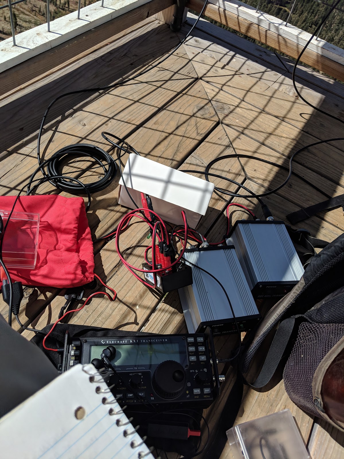
If you continue on the road over and past the summit, the trees stop and there are great views. This is where I stopped and set up. I had decent cell coverage on the summit, and was able to spot myself. (2022 update: Verizon service was very spotty. I'd get a spot out, then lose service, then sometimes it would come back after a while. Rely on it at your own risk!) I worked the usual bands. I had a large pileup on 30, and got four summit-to-summits there. After, I did VHF and worked stations in Fresno on both 2 and 440!

Mt Stakes dominated the view to the east.

As I was packing up a group of girls arrived, but left before I was done packing. I passed them on the way down. I retraced my steps back to Poverty Flat, but decided to take the Cougar Trail up to Manzanita Point, then the Springs Trail back to Coe Ranch. The climb out of Poverty Flat was rough, but it wasn't any worse than I had feared it might be.

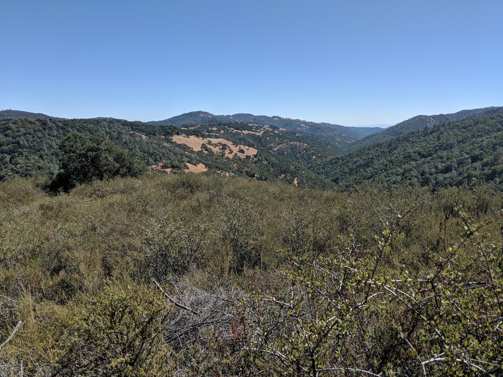
That might be Wasno Ridge, I didn't stop long enough to figure out all the peaks.

Once I was back on Pine Ridge, the cool breeze picked up again and I cooled off. Back at the car I headed down the windy road back to Morgan Hill.

Trailhead: Coe Ranch. This is the park HQ.
Website: SOTA Site.
Maps: AA6XA SOTA Hikes map.
Route: Corral Trail, Forest Trail, Poverty Flat Road, Jackass Trail, Blue Ridge Road. Going via Hobbs Road might be shorter, but there are some extremely steep sections on that road that I really dislike.
Red Tape: None.

Red Hill and Basalt Hill were visible. Burra Burra Peak too, I think.

Monday, September 10, 2018

W6/NS-195 Grouse Ridge

This is an excellent peak. If it is not a clear day, don't come up.
Looking North.
Drive up Grouse Ridge Road, 14. It is dirt, and rough in places, but my poor little sedan made it. I was going to camp there at night, so I claimed a site and set up my tent. I then grabbed my backpack and bag and walked up to the summit.
Watching the North Fire burn.
It is a trivial walk up to the top. There is a sign on the lookout saying that it is being repaired and will someday be open for overnight rentals. I clamed a corner of the deck and got busy putting up my VHF stuff. I had two Yagis, and a 6/HF antenna to put up, as well as two transverters to hook up.
Majestic looking antennas.

What a mess of cables!
On the air I quickly began filling the log with contest stations. I got the most contacts on 2 meters, as I expected. 50MHz was deader than I expected. This could be in part because of the bad antenna I was using for the band. I haven't found a good solution for a portable antenna for this band. Once I found the offsets for the transverters for 220 and 440 I made some weak signal contacts on each band.
I think that is smoke on the horizon from the fires north of Redding.
When VHF activity slowed down, I worked some normal chasers on HF. Considering how accessible this peak is, I was surprised how few people I saw while I was on top. After about 4 hours the action had died down, and the sun was starting to set, so I packed up.
I think those are the Sierra Buttes.
Back at the campsite I had dinner and settled in for the night. Someone with some foresight had placed the campsite on the lee side of the hill. Thank goodness. The next morning I drove up to the Donner Summit area for a rogaine.
View from my campsite.
Trailhead: Grouse Ridge CG. TH parking is just above the CG.
Website: SOTA Site.
Maps: AA6XA SOTA Hikes map.
Route: Follow the road up to the lookout.
Red Tape: None.
The road, just below the lookout.

W6/NS-296 Clyde Mountain

Clyde Mountain is a relatively easy peak near Lake Spaulding. WB0USI posted some directions to get to the top, but I found them hard to follow. I took his suggestions of parking in a small pullout past the dam of Fuller Lake and then went my own way.
Car parked in a small pullout.
After parking I just went straight up the mountain. The bottom is fairly open forest, and I had no trouble going up. I crossed an abandoned road a few times, probably the one Rick mentions.
Under the power lines.
About 120' below the summit I encountered some dense, waist-high brush. This slowed me down some, but I was able to just power through it. I got a few cuts on my legs, despite wearing pants, but they were inevitable when I started bushwhacking. I got to the summit ridge just north of the summit, and pushed through the manzanita the last few vertical feet to the high point.
The top of this rock appeared to be the highest point.
On top I set up my antenna and was on the air. I had good cell service. As I operated I watched the North Fire burn, a few miles away on the other side of I-80. I didn't linger, since I wanted to get up to Grouse Ridge for the VHF contest later. After finishing radio stuff, I went straight back down the mountain.
Lowell Hill Ridge is very close, but on the other side of a canyon.
I managed to pop out of the woods right at my car, which was a welcome sight. I then continued up to the next summit.

Trailhead: Bowman Road, past the Fuller Lake Dam.
Website: SOTA Site.
Maps: AA6XA SOTA Hikes map.
Route: Go straight up. Its not too steep.
Red Tape: None.
No dense brush ever stopped me (except on Pk 4850)

W6/NE-015 Mt Bidwell

This was the last peak of my Warner Range trip. After spending the night at the Cave Lake Campground, I continued up the rough road to the trailhead.
Cave Lake at sunset.
A short distance up the trail I walked past Moonlight Mine, an abandoned mine.
The biggest building of the mine.

The privy was sinking into it's pit.
The road got rougher after this point, but it was easy to follow. Up at the top of the first hill there was a wet section, but I was able to get across without getting my feet wet. Some cows ran away as I hiked up.
Some of the cows on the way up.
The summit is fairly bare, but I found some rocks to support my pole. I got setup and got on the air. K6ARK had planned to do his goat activation, but I was too early to work him. I did a quick activation, then hiked back to the car. I had a long drive home ahead of me, and didn't want to get back too late.
Looking down at the mine.
Trailhead: Intersection of 2 and 48N21
Website: SOTA Site.
Route: Walk up the roads, past Moonlight Mine.
Red Tape: None.

Friday, September 7, 2018

W6/NE-059 Sugar Hill

Sugar Hill was the easiest mountain I did during my Warner trip. It is a drive up peak, with an old lookout tower and pit toilet on the summit. I drove over after hiking Bald and Cedar Mountains. The roads were in good shape, except for one rough one that I took.
A sad looking tower. Lots of glass on the ground from the broken windows.
The tower is closed and fenced off. It appears it is used to hold up antennas now. I setup in the shade it provided, since it had turned into a hot day. I had my KX3 and microphone, since it was a drive up. I made contacts on the usual bands, but added in some sideband to change things up a bit. It was much harder to make SSB contacts than CW.
Antenna on a hazy summit.
It had also gotten very hazy, and I could barely see Goose Lake below me. This summit probably has great views on a clear day. Just before I left, a guy rode up on a dirt bike, then lamented that he wouldn't be able to take good pictures since it was so hazy. I commiserated with him for a few minutes, then left to head up to Cave Lake Campsite, my destination for the night.
Nothing makes a summit scenic like a chain link fence and toilet.
Trailhead: I parked near the toilet.
Website: SOTA Site.
Route: Drive up to the summit. Set up somewhere.
Red Tape: None.

W6/NE-292 Cedar Mountain

After activating Bald Mountain I continued along to get Cedar Mountain. The two peaks are connected by a ridge. The walk down to the col from Bald was pleasant, a wide, shallow ridge.
Looking at the descent from Bald.
Near the col, the cliffs start. Luckily they are not in the path, but they are nice to look at from the top as you hike along.
Some of the cliffs, on the east side of the ridge.
On the Cedar side of the col, the brush starts to pick up. It is not too dense, and didn't slow me down much. The last climb up to the summit is through the forest on a steep slope.
The summit is behind those pine trees.
It took me 45 minutes to traverse from Bald to Cedar. The summit is open, and there were a lot of flies buzzing around while I was up there. After taking a few pictures, I set up and got on the air. Plenty of cell service like most of the other peaks here. Once the chasers had been satisfied, I retraced my steps back over Bald and to the car, where I drove to Sugar Hill.
Summit of Cedar Mountain.
These two mountains are some of my favorites from this area of California. I wouldn't mind coming again to hike them.

Trailhead: Intersection of 46N30 and 44N67.
Website: SOTA Site.
Route: Take the road up to the ridge. Where the road ends, stay high on the ridge and continue up to the top.
Red Tape: None.

W6/NE-017 Bald Mountain

Bald and Cedar Mountains are in the middle of the Warner Range, just north of CA 299. I spent the night camping at the trailhead, and got an early start.
Waiting for dinner time.
The campsite is a few yards downhill from the road. In the morning I packed up and headed up the hill. The road doesn't see much traffic, but it was easy to follow up to the ridge. This climb is through the forest. On the ridge I turned left to continue up to the summit.
Bald on the left, Cedar right.
The forest soon ends and the hike up is through the open ridge. The road continues up before ending a few hundred feet below the summit. I made the mistake of following a herd path along the side, a bit below the top of the ridge. This ended in some thigh-high brush which was unpleasant to walk through. Stay near the top of the ridge for easier going.
Getting closer to the summit.
I got out of the brush, and made my way to the summit. There is a small stone windbreak, and a USGS marker. It was a fairly easy hike up, with great views along the way. I used the windbreak to hold up my pole, and got setup. K6ARK was on a peak, and we tried to get a summit-to-summit, but I couldn't hear him. I then put out a spot and quickly filled the log.
Benchmark at the summit.
 After finishing up, I packed up to continue along the ridge over to Cedar Mountain, the next summit of the day.

Trailhead: Intersection of 46N30 and 44N67.
Website: SOTA Site.
Route: Take the road up to the ridge. Where the road ends, stay high on the ridge and continue up to the top.
Red Tape: None.
Heading over to Cedar, in the background.

W6/NE-026 Buck Mountain

Buck Mountain was the final peak for the day, day three of my Warner Mountain trip. After stopping in Alturas to refuel and get some snacks, I drove up the nice gravel road towards the peak. The road got a bit rougher closer to the peak, but it was still in good shape.
Small pond (marsh?) by the road.
The FS map shows a small marsh next to the main road. Just north of this is an abandoned road, which it turns out runs right to the summit. The road is easy to follow. It had a few steep sections, but was generally well graded.
Getting close to the summit.
There is a long flat section just below the summit. The summit is unremarkable. I sat under a tree and ran my antenna out away from me. Surprisingly the cell service was intermittent on top. I was able to get out some text spots, and got the usual chasers.
On my way back to the car.
Back at the car I drove back down the road to the trailhead for my next hike, up to Bald and Cedar Mounains.

Trailhead: Unmarked road by marsh, along 46N30.
Website: SOTA Site.
Route: Take the abandoned road up to the summit.
Red Tape: None.
View from my campsite that evening.