Monday, September 18, 2017

W6/CC-046 Loma Prieta

Loma Prieta is the highest mountain in the Santa Cruz Mountains, that run from San Francisco to Santa Cruz. Because it is so high and prominent, it is easy to get close to the peak in a car. However, the roads near the top are narrow and windy. Not a good place to bring your giant car or trailer. After spending Sunday morning orienteering at Big Basin, I drove up to activate Loma Prieta. There is a large area you can park at approximately 21922 Loma Prieta Ave, and this is where I started my hike from.
Loma Prieta. It looks like the fire line went over the summit.
From here, head up Loma Prieta Road. This is mostly dirt, with a few sections of beat up pavement. A fire burned through here recently, and the trees have not recovered yet, but the undergrowth is looking healthy. It was also easy to see where the firefighters had built the fire lines. There are great views along the road on the way. I saw a total of three other cars while I was out, two on the way up, one while coming down. At the next intersection, continue on Loma Prieta Road. This dirt road obviously heads up towards the summit. Near the top there are a few other roads that branch off, but its not hard to get to the high point.
Mt Um in the center. It was opening weekend for the peak.
There are a lot of towers on top, but I found an old concrete slab to set up on. It was almost as good as having a picnic table at the top. I started on 30 meters after sending out a spot, and got three contacts. I called for a while on 20 and 17, but didn't have any luck. My HT was able to deal with all the RF on the summit, at least on 2 meters, and I made a few more contacts there. I called a bit on 7-ssb, and did get one contact eventually.
Looking west from the summit.
I had had enough radio at this point, so I packed up and headed down, back the way I came. Others had reported rangers giving them a hard time, but I didn't see any officials while I was out.

Trailhead: Large pullout near 21922 Loma Prieta Ave. Could also park at intersection of Loma Prieta and Loma Chiquita.
Website: SOTA Site.
Maps: AA6XA SOTA Hikes map.
Route: Take the road to the summit. It was obvious which road to take.
Red Tape: Signed that its open to residents only. (Residents of where?)
El Toro through the haze. 1509 is the ridge to the right.  Twin Peaks out of the frame to the right.

W6/NC-376 El Toro

El Toro is a distinctive peak towering over Morgan Hill. The east side of the mountain is on public land, but the actual summit seems to be just outside this. After spending the morning climbing West Twin Peaks I came over for an easier summit. I parked at the bottom of the West Hills Community Church driveway. The gate was open, but I didn't want to get stuck on the wrong side if it was closed while I was hiking. In the corner of the parking lot at the top there is a trail that heads uphill. This leads to the summit.
Gate, small parking area on the right.
The first part of the trail switchbacks up the side of the hill on a fire road, until it reaches the crest of the ridge. Here it follows the ridge up to the summit. The final steep section has a rope that can be used to assist in ascent and descent. Its probably not necessary, but it made me feel better to use it.
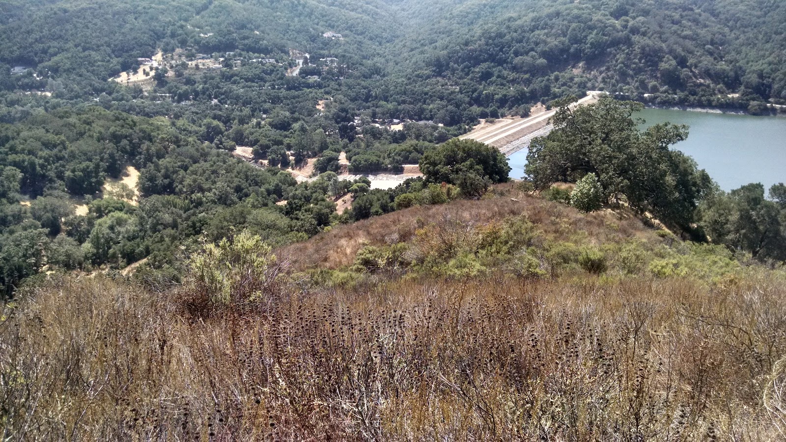
El Toro summit.
The top is covered in dense brush, and the only place to set up was on the trail. As I was coming around the final bend at the top, I heard what sounded like CW coming from the bushes. Oleh, KD7WPJ, was setup and operating! This was the second time that we had met on a summit, the first was on Kratke Ridge, down in the San Gabriel's. He was on 20, so I setup my loop and got on 30 meters. I had good luck, and quickly made five contacts. We then switched, but there was a lot of noise on 20, so I went up to 17. The first station to answer my CQ was ZL1BYZ in New Zealand, with a very strong signal. After having such good luck on 17, I decided to try 15 as well, but didn't get any DX.
Operating among the poison oak.
 Oleh was getting ready to go down, so we checked to see if we could make a contact on 2 meters after he left the AZ. Tuned to the calling frequency, we heard AA0BV calling from Santa Rosalia Mountain, a few miles away. Oleh tried to answer, but AA0BV wasn't getting any audio, so I tried to make a contact. He could hear me, but my HT couldn't hear him well. In the end, it took two radios, one for transmit and one for receive for both of us to get a summit to summit.
Looking towards Loma Prieta and Mt Um.
After he left, I tried 20-ssb, then 5-cw, and made one contact each, including another summit to summit on 60. I was getting tired and hungry, so I packed up and headed back down the mountain. The descent down the rope was not difficult, and I was soon back at my car.

Trailhead: West Hills Community Church. Park below the gate unless you're sure it will be open when you return.
Website: SOTA Site.
Maps: AA6XA SOTA Hikes map.
Route: From the back corner of the parking lot, follow the fire road uphill to the summit.
Red Tape: None.

W6/NC-356 West Twin Peaks

West Twin Peaks is a mountain at the south end of the Santa Cruz Mountain range, west of Morgan Hill. Most of the mountain is private property, but the face above Uvas Reservoir is public, and this is the side I climbed up. I parked in a large pullout across the street from the dam, then walked across it. It is possible to go around the fences at the spillway if the water is low enough. If there is high water, it would be dangerous or impossible to get across the spillway.
Dam, with ridge I climbed on the left.
Once on the other side, I started uphill. There were some old animal paths that I was able to follow, which made it much easier to push through the brush. The sections of trees were a nice break from pushing through the brush. Partway up I found and old road bed that is not on any of the maps. This appeared to contour around the hill, and rejoin the ridge on the other side of the sub-peak. I started to take it. However, a short distance down it, I came around a bend to find a skunk with its tail up, standing in the middle of the path. I quickly backed up, and gave it a few minutes to clear out of the area.
This is as close as I was willing to get to the skunk with my camera.
I then cautiously started up the old road again, only to find the skunk still standing in the middle. Not willing to risk being sprayed, I decided to follow the crest of the ridge, which had been my original plan. I made it past the sub-peak, marked 1257 on the USGS quad, and started the final push up to the summit.
This sort of brush is not fun to push through.
The summit cone was covered in a taller, denser brush, and it was slow going if I didn't have a herd path to follow. I would recommend wearing long sleeves and gloves if you come up this route, my arms got cut up. Eventually I made it to the summit. There was a small clear area, with views to the north and east where I set up to operate. I made eight contacts on 30, 20, and 17 meters. My calls on VHF were fruitless. I had a good 4G signal at the top.
El Toro, my next SOTA peak for the day.
 After I had finished operating, I packed up for the slog back down. I think it took the same amount of time to get back down as it did to get up, the brush was so dense. It was a relief to break out of the brush at the bottom and walk across the dam. I then drove over to El Toro, for a second SOTA activation. I had been worried that it would be too steep to get up or down, but the grades were reasonable the entire way. There were a few cliffs and other really steep sections, so some planning is required to avoid these areas.
Part way down, looking back at the summit.

Trailhead: Pullout across the street from Uvas Reservoir Dam.
Website: SOTA SiteCounty Park site.
Maps: AA6XA SOTA Hikes mapCounty park map. Shows public land boundaries.
Route: Cross the dam. Bushwhack up your selected ridge to the summit.
Red Tape: None. May be impossible to cross spillway during high water.
Dam and spillway.

Monday, September 11, 2017

W6/NS-395

This unnamed peak is just north of the Sierra Buttes, north of Sierra City. I climbed it after stopping by a small peak above Downieville. The best trailhead is at Packer Lake Saddle, at the top of county road 621. The road is paved to this point, and although steep and narrow, easily accessible in a normal sedan. There is a small dirt lot at the top with room for a half dozen cars. This was full when I arrived, so I parked in a small area on the other side of the street.
Parking area and trailhead (PCT).
 As I was repacking my stuff and getting ready to leave, a man who was obviously a thru-hiker emerged from the woods. I started talking to Wookie, and gave him some water and a bag of chips, and he told me about his hike so far. It was a great way to start the hike. The hike simply follows the PCT north until you turn off the trail for the final climb up to the summit.

Sierra Buttes, to the south.
The trail is well worn and well graded, and it was an easy hike. It is an open forest near the peak, so the off trail section was easy. I could even watch the hikers below as I operated. The summit is a very narrow section of rock, so I setup on a flat spot on the west side of the crest. I quickly got my antennas up and got on the air.
2m/70cm yagis, doublet at the top of the pole.
Despite the contest going on, I had trouble making contacts. I thought that my height would give me a great advantage, and there would be a steady stream. I got a bunch of stations in the Sierra and Central Valley, and a few on some of the hills in the Bay Area. I discovered that the Powerpoles I had put on the cable for my new 70cm transverter had fallen off. I was able to shove them back in well enough to make a few contacts on the band.
Deer Lake, looking north.
After so many SSB contacts, I went down to 30 meters to see if I could scare up some CW contacts. I got one, and had a nice conversation with a fellow down near Nevada City. A few times some clouds passed overhead, and I was worried it might rain, but all they did was block the sun and keep me cool. It was getting late, and I didn't want to have to hike down in the dark, so I packed up and headed back the way I came.
Looking south east from the summit.
As I drove down and through the mountains to my campsite, I enjoyed the Sierra sunset and beauty. I had been concerned that there would be smoke and haze from nearby fires, but it was crystal clear in this area.
Switchback on the way down.
Trailhead: Packer Lake Saddle.
Website: SOTA Site.
Maps: AA6XA SOTA Hikes map.
Route: Pacific Crest Trail north. When the trail starts going downhill near the summit, turn off the trail and bushwhack up to the top.
Red Tape: None.
At the operating position. True summit behind me.

W6/NS-337

This unnamed peak is a small hill above Downieville that is an easy hike. I parked at what Google calls the "Downieville Public Utilites." There was a small pullout with room for a few cars, but it was full, so I parked on the side of the road behind another car.
Trailhead to the right, behind the building.
Behind the building is a dirt trail, apparently popular with mountain bikers. There is a sign at the trailhead. I took this up the hill to where it turns sharply to parallel the river. Here I turned and climbed up the spine of the ridge. This area appears to be popular with the locals, I passed many old fire pits and sawed off trees.
Typical scene on the hike.
After the initial climb, it levels out and climbs at a moderate grade. There are some rocky sections, but I didn't have trouble getting over them. Make sure you don't stop at the false summit on the way up. There are plenty of trees in the activation zone, so no need to bring an antenna support. I did not have any cell service, in town or at the top, so no easy way to spot. I had set an alert, and after a few CQs the RBN and SotaHole spotted me. I quickly worked seven people on 30 meters, all usual chasers. I had been reading reports of solar activity that would kill the bands, but 30 seemed to be as open as it usually is in the morning.
Somewhere along the ridge.
I didn't spend much time on the summit since I wanted to climb a second, higher peak and participate in the VHF contest that was about to start. The climb down was quick, though the leaves on the ground were slippery in places. I made it back to the car for the drive over to Peak 7569.

Trailhead: Behind Downieville Public Utilites. If no parking available here, park downtown and hike up Main Street.
Website: SOTA Site.
Maps: AA6XA SOTA Hikes map.
Route: Take First Divide Trail, then turn and hike up the hill. Ridge is very easy to follow.
Red Tape: None.

Tuesday, September 5, 2017

W6/NE-147 Mitchell Hill

Mitchell Hill is a small peak east of the town of Madeline. From US 395, I drove up to the height of land on Clarks Valley Road. There is an open space on the north side of the road where I parked and camped for the night.
Formation on the other side of the road. Useful for finding my way back.
In the morning I packed up, then headed up the hill. There is only one hill here, so just walk up it. There were a lot of areas of jumbled rocks, and after a few minutes walking across them I remembered all the skills I had gotten hiking in NH. It took me just over 20 minutes to get to the top. The highest point was covered in dense branches, so I set up an a clearer area to the west.
The sun was still rising as I got on the air.
After setting up, I decided to try 15 meters first. Eventually I got a contact to Florida. Moving down to 17 meters got me three more. This was the only peak I had planned for the day, so I spent some time calling on more bands and modes. 20-ssb got three contacts, including W0MNA and W0ERI who were surprised to hear me on sideband. 30 meter CW got the bulk of the contacts. I also got two on 60 meters. Finally I called on 40-ssb and got my last contacts. After that I tried 15 and 80 meters, but didn't have any luck on either.
New setup with the Palm Pico Single and big LiPo.
By this point the sun had come over the hill, and it was getting hot. I was also tired of sitting on the rocks, so I packed up and headed for the car. I managed to come out of the woods right where the car was. Sometimes I impress myself.
Lots of rock fields like this on the mountain.
Trailhead: Height of land, Clarks Valley Road
Website: SOTA Site.
Maps: AA6XA SOTA Hikes map.
Route: Hike up the hill. No route is obviously better than another.
Red Tape: None.
Smoke from a fire somewhere. Those hills are only a few miles away, as the crow flies.

W6/NE-006 Hat Mountain

The high point of Lassen County is Hat Mountain, not Lassen Peak as one would expect. I climbed Hat Mountain the day after climbing Eagle, Cole, and Emerson Peaks. There is no trail to the summit, so I followed a route described by others on its Peakbagger page. I drove down fire road 38N18 to its junction with 38N18A. A vehicle with higher clearance than my sedan could continue down 18A.
Road junction at the start of the hike.
I followed 38N18A to its end, where it peters out in a marshy area. From here it is a steep and dense bushwhack down to Lost Lake. I made it down without too much trouble, and was able to cross the outlet stream without getting my feet wet. I then walked across the dam/road to the base of Hat Mountain.
Lost Lake in the early morning sun. Hat mountain to the photographer's left.
From the lake to the summit is a 1500 foot vertical climb, through some very steep forests. Careful study of a map will reveal sections that are a bit less steep, and they generally seem to be forested. Near the top, at the end of the forest is thigh-high scrub that is difficult to push through. On my way down I avoided this by staying higher on the ridge.
A hot and sweaty hiker has another county HP and SOTA summit!
There are a few piles of rocks  at the edge of the cliff, and the southern one is the highest. It has a register, which I signed after noting I was the first person in 2017 to sign it. I would have thought more people would have climbed up already this year. I setup my antenna, strapping the pole to a tree, and got on 20 meters. I quickly got six contacts. Since I had a good cell signal, I spent some time working other activators, getting three summit-to-summits. KX0R was really booming in on 30.
The tree that supported my pole. Thank you tree.
After having enough, I packed up for the long hike back. Going down was much faster, and the slope was not too steep, or so it seemed. I retraced my steps across the lake's dam, then began the ascent back up to the meadow and fire road. This was unpleasant, and the brush seemed much denser than on my way down. I eventually fought my way up to the road, and walked back to my car.
Tunnel of aspens on 18A.
I passed a truck driving up the road. A few minutes after I got back to my car, it returned and started down 18. I'm not sure what he was up to. I was hot, tired, and hungry, so I spent some time sitting in the shade eating and drinking. It was getting hotter and I was quite tired, so I decided not to attempt Horse Mountain. I drove into town to head over to the trailhead for tomorrow's hike.
Eagle Peak, Horse Mountain on the right.
Trailhead: Junction of forest roads 38N18 and 38N18A.
Website: SOTA Site.
Maps: AA6XA SOTA Hikes map.
Route: Follow 38N18A to the end, then follow stream down to Lost Lake. Bushwhack up to the peak. All routes are steep.
Red Tape: None.

W6/NE-004 Emerson Peak

Emerson Peak is another of the high peaks in the southern part of the Warner Range. I climbed it after activating Eagle Peak and Cole Peak. From the Eagle/Cole col, I retraced my steps along the Summit Trail. At the col between Emerson and Peak 8742, I stepped off the trail and began to bushwhack up to the summit.
First glimpse of the summit through the trees.
This was fairly straightforward, going uphill, but I did want to avoid going over the small sub-peak. I was also running low on water at this point. Eventually the cooler forest ended and I had to hike up the final part in the full sun. At the top, I signed the register. Someone noted that if you stood on the cairn and jumped, you could get above 9000 feet. I didn't try. Once again I strapped my pole to one of the short trees and got on the air. I had a decent signal, so spotting was no problem.
Looking towards Hat Mountain, tomorrows destination.
I quickly got plenty of contacts on 20. The hardest part was dealing with the ladybugs that were swarming around. It got annoying. After packing up I tried calling my girlfriend, since there was no service at the campsite, but the signal wasn't good enough for that. Hot, tired, and thirsty I headed down the ridge, back to the Summit Trail. Eventually I found the trail, and followed it as quickly as I could back to the campsite and my store of water.

Trailhead: Patterson Campground/Guard Station. There are pit toilets, but no water.
Website: SOTA SitePatterson CG Site
Maps: AA6XA SOTA Hikes map.
Route: From Eagle Peak, Summit Trail, to col between Emerson and Pk 8742. Bushwhack to the summit. Direct from Patterson, take Summit Trail, then bushwhack up past Bearcamp Mountain.
Red Tape: None.

W6/NE-005 Cole Peak

Cole Peak is one of the high peaks in the South Warner Wilderness, in Modoc National Forest. I climbed it on a three-summit day, after Eagle Peak, and before Emerson Peak. Compared to Eagle, the ascent is a walk in the park. From the col between the two peaks, go cross-country up to the summit. The slope is gentle and wide.
Me and Eagle Peak. Eagle Peak really dominates the area.
It was hot out, so I stayed in the trees as long as I was able to. This kept me closer to the cliff edge, with views back to Eagle. I was able to watch the two other climbers I had passed making their way up. There are a few areas that could lay claim to being the highest point, and I went to two of them. I didn't see any summit register to sign. After looking around, I found a shady spot to set up in. I used a tree to hold up the pole, and got on the air.
Typical scene from the summit.
Again I got on 20 meters for all of my contacts. I tried VHF too, but I don't think there are enough people around here to make it easy, unlike the Bay Area. I didn't have any cell signal from my operating position, but walking to the edge I could get a very strong 4G signal. After packing up I retraced my steps down hill, and back to the Summit Trail.
North Emerson Lake. There is a different trailhead down that way.

Trailhead: Patterson Campground/Guard Station. There are pit toilets, but no water.
Website: SOTA SitePatterson CG Site
Maps: AA6XA SOTA Hikes map.
Route: Summit Trail, to unmaintained trail at col. Cross-country uphill to the summit.
Red Tape: None.

W6/NE-001 Eagle Peak

Eagle Peak is the high point of Modoc County, the South Warner Wilderness, and the Warner Mountains. Because it is a county high point, it is fairly frequently climbed. The Peakbagger page has a number of other trip reports. I had camped the night before at Patterson Campground, which is at the south trailhead of the Summit Trail. I had an ambitious three-peak day planned, so I woke up and left early.
Me and my destination. Most of the trail hike was in the shade, because of the peaks to the east.
 Once I had climbed up to the ridge, I started to get views of the peak. It is very large, and very impressive looking. It took me about two hours to get to the junction with the unmaintained trail that goes over the saddle. From here, I found a good point to leave the trail and start the ascent.
Ready to go up.
The bottom section is open, with small scrub that is difficult to push through. Luckily it is fairly low, so one can step over it. The really steep part doesn't start until the trees in the above picture. That is also the section where the loose gravel starts. I was glad I had brought my hiking poles. There were a few sections that were steeper and more exposed than I would have liked, but I got past them. Eventually, I made it to the top. I found the register, and signed it.
Partially set up antenna. Lots of smoke in the distance.
There are lots of low trees on the west side of the hill, and I used one to support my pole and antenna. After having a snack, I got on 20 meters. There was a very good 4G signal (Verizon) on the summit. I quickly got nine contacts in the log. I thought I'd try VHF since I was so high, but the only contact I made was when someone re-transmitted my signal on 446 through a local repeater. I still wanted to get Cole Peak and Emerson Peak, so I didn't hang around on the summit too long.
Cole Peak. Emerson Peak out of the frame to the right.
On my way down I took a more westerly route, staying in the trees for longer. This felt safer, probably because I couldn't see so far down the slope. At the bottom I passed two guys who were about to head up. I gave them my thoughts, then continued around to Cole Peak.

Trailhead: Patterson Campground/Guard Station. There are pit toilets, but no water.
Website: SOTA SitePatterson CG Site
Maps: AA6XA SOTA Hikes map.
Route: Summit Trail, to unmaintained trail at col. Cross-country uphill to the summit. Cross-country section very steep.
Red Tape: None.
Looking North. I think that is Warren Peak in the far distance.

W6/NE-295

This unnamed peak looks over Blue Lake in Modoc National Forest. The drive in to Blue Lake is easy, the roads are all paved to the campground. My original plan was to park at the campground, on the south-east side of the lake, then hike up, but there were no parking spots there. Instead I parked in the day use area on the north end of the lake.
Trail around the lake. Edge of the summit ridge on the right.
There is a paved trail that runs around the lake, and I took this to the campground. From the south end of the campground I went cross-country. I crossed the first fire road, and continued bushwhacking to the second. I followed this road, 38N60, up the hill to the pass. Here I crossed over and continued up to the summit along fire road T60AD. All of the roads, up to the last one, were in good condition, and a bike or ATV could easily drive up them.
Blue Lake.
The last road was overgrown, but easy to follow. It eventually petered out near the top, but it was easy to continue ascending through the open forest. There are a few knobs on top that could have been the high points. The summit area is large and fairly flat, with a very large AZ. I setup near a downed tree, using it to support my pole.
Setup at the summit.
I had a strong 4G signal on top, but none down at the lake. This was the pattern all weekend I was up in the area. It was late in the afternoon, so I got on 30 meters and quickly got five contacts. I then went down to 40, and got a few more. I wanted to get down well before dark, so I could drive over to my campsite and setup in the light, so I called it quits. Finding the road I had taken up was easy, and then a quick walk back to the lake. I saw a number of deer, and cows, but the deer were too quick for me to get a picture.

Trailhead: Blue Lake. Either the campground or day use area. Both have pit toilets.
Website: SOTA SiteBlue Lake Site
Maps: AA6XA SOTA Hikes map.
Route: Trail along lake shore, then cross country to 38N60. At pass, take T60AD, then bushwhack to summit. I did not see road numbers while hiking, so take a map.
Red Tape: None.
Near the summit. That's Eagle Peak on the right.