Tuesday, July 17, 2018

W6/NC-521 Chalk Mountain

Chalk Mountain was the last SOTA peak in Santa Cruz County I had left to climb, and it is a beautiful one. It is the only peak in the county with a view on the summit. The shortest access seems to be from Whitehouse Canyon Road. This road is unpaved and somewhat rough, but I had no trouble in my sedan. Drive down the road until the wide area, with the sign marking the end of public access. The hiker trailhead sign is much easier to see from a distance.
The parking area, TH on the right.
The trail starts out up a beautiful, redwood canyon, climbing rather steeply.
Up the side of the hill.
There are two junctions you pass by, each leading to a viewpoint. The lower one was nice, but I wasn't able to follow the trail to the upper one. At the top of the hill, the trail ends at a fire road. Turn left onto the road, and follow it to the summit. The road goes over a sub-peak that is nearly as tall as the main one.
View of the summit from the sub-peak. Chalk Peak is the bald one nearby, with McAbee and Pine behind it.
Just below the summit the road forks. Take the right fork up to the top. There is a tower, and a small privy just below it. The views from the top are excellent, but only a few mountains are visible. Some high ridges block the view to the east and south. There is a picnic table in an open area to the west. 2019 note: The table is still there, despite what other activators might try to tell you. I setup at the table, stringing out my antenna down the access trail. There was good service, at least at the table.
A nice view of the ocean while operating.
I was expecting a lot of chasers, but I only got five on HF. The ionosphere must not have been cooperating. After getting everyone, I called on VHF, and got two contacts up in Gualala, which is on the Sonoma-Mendocino county border, about a hundred miles north over the ocean.
Looking over Castle Rock and Big Basin. Mt Bielawski on the left, McAbee in the center, with Pine Mountain just to the right of it. Buzzard's Roost is the pointy summit near McAbee.
Before going down I enjoyed the view from the summit a bit more, then noticed something. The privy was facing the wrong way. If it had been turned 90 degees, one could have enjoyed a great view while sitting in it. As it is set up now, the only view you can get is of a white fence. It looks like the structure is sitting on a concrete pad, so it might not be too much work to rotate it for a better bathroom experience. At least the builders of the North Chalone privy got it right.
Its a scenic privy, but no view while sitting on it.
The hike back down was nice, especially when I got back into the cool shade of the redwoods. The trail seemed even steeper going down than it had on the way up, but it made the hike quick. Back at the car I navigated the bumpy road out, then enjoyed a drive up the coast to get to a road that crossed the mountains back to the Bay Area.
Saw this tag on the ground in the parking area.
Trailhead: End of the public part of Whitehouse Canyon Road.
Website: SOTA Site.
Maps: AA6XA SOTA Hikes map.
Route: Take the trail up through the redwood forest. Turn left onto the tower access road and follow it to the summit, bearing right just below the high point.
Red Tape: None.

Monday, July 16, 2018

W6/NC-373

This peak is one of the uninteresting drive-ups in the Santa Cruz Mountains. I think of this peak as Jackrabbit Peak, since Jackrabbit Road leads to the top. The high point of this peak is in someone's backyard.
On the air.
I took 17 south to Glenwood Drive, to Weston Road. Weston appears to be a private road, but the gate was wide open when I went. Near the top of the hill I turned onto Jackrabbit, and drove up to the top. There is a section of the road that is in the activation zone, and I parked and operated from here.
Not a scenic summit.
There was plenty of service, and I had no trouble sending out spots. I did have trouble getting chasers, though I did get five eventually, on 30 and 20. After working everyone who called, I packed up and headed down, over to Chalk Mountain, the nicest one of the day.

Trailhead: Top of Jack Rabbit Ridge Road
Website: SOTA Site.
Maps: AA6XA SOTA Hikes map.
Route: Drive up.
Red Tape: None.

W6/CC-062 Santa Rosalia Mountain

This was my second time up to this summit for an activation. The first time, two years ago, it was the very first SOTA activation I had ever done. I had not carefully read the map, and ended up hiking over 20 miles, having started near Aptos. This time, however, I was more prepared.
Up the road.
I parked at the Highland Way - Buzzard Lagoon Road intersection, and set off up Buzzard Lagoon Road. As others have noted, it is well graded for the first mile or two, and easily drivable, but I wanted a walk. After around a mile I turned right onto the Aptos Creek Fire Road. This road is steeper and rougher than the first road.
Up on the summit ridge.
The trail was nicely shaded for most of the hike, and I only saw a few bikers while on my way up. The fire road goes around the true summit, but there is a use trail that goes up the last few feet to the high point. There is no point that is definitely the highest, so I walked around a bit until I found a good area to set up in.
View from the operating position.
As soon as I stopped walking and put my bag down, red ants started crawling over it and me. I looked around for a better place to set up, but I didn't see any ant-free locations. Instead I just put up my antenna and stood for the activation. I had no cell service on top, so I relied on RBN to spot me. It did after a few CQs, and I quickly got four contacts into the log. Since the ants were so bad, I didn't try other bands, I just packed up and hightailed it out of there.
The only view, of a fog-covered Monterey Bay.
The hike down was quick, and I passed a lot of bikers heading up and down. Just after passing the sign marking the park boundary there was a van unloading a bunch of people and bikes. They were probably going to bike downhill back to the coast, which seems like it would be a fun ride.
Happy to be out on such a nice day!
Trailhead: Highland Way-Buzzard Lagoon Road intersection.
Website: SOTA Site.
Maps: AA6XA SOTA Hikes map.
Route: Take Buzzard Lagoon Road up, then turn right on Aptos Creek Road.
Red Tape: None.

W6/NC-335

The summit of this peak is in a backyard, but it is still possible to get into the activation zone. Near the top of Tindall Ranch Road there is space to park and setup. I left my house early in the morning, and got to the summit before the sun had made it over the ridge. The road up to the top is very narrow and steep, like many roads in the Santa Cruz Mountains.
Parking spot. 
I parked across from the driveway to the Split Rail ranch, which my topo map showed to be inside the activation zone. I setup my mag loop a few feet in front of my car, and got on the air. I had trouble matching it on 30, so I only worked 20 and 40. After getting four contacts on each band I packed up.
Setup and on the air.
This is not a very interesting summit, and I only did it for completeness, as it was one of three remaining summits in Santa Cruz.

Trailhead: End of Tindall Ranch Road.
Website: SOTA Site.
Maps: AA6XA SOTA Hikes map.
Route: Drive up.
Red Tape: None.

Tuesday, July 10, 2018

W6/NS-347 Quiggs Mountain

Quiggs Mountain is a drive up summit in the foothills of the Sierra Nevada, near the town of Mountain Ranch. I was coming from CA 88, so I put on the GPS and blindly followed it. The route it took me was down some very narrow roads, both paved and dirt. I was a bit concerned that I would have to turn around, but the dirt roads were well graded.
View of the summit.
There was obviously a fire here a few years ago, but I couldn't tell if any of the ranches had burned. Eventually I got as close as I could to the summit, just below it. The road to the top is fenced off and signed, but there is a large pullout just before the fence. I set up here. It was much hotter and sunnier than it had been in the mountains the previous days, so I didn't linger. I was expecting a large pileup since it was Saturday morning, but I didn't get one.
Setup next to the road.
After I worked all the chasers I packed up and drove home. This time the GPS took me through Mountain Ranch, and the road down to it was much better than the way I went up. This is the route I would recommend. Since there are so many towers on top, it is probably possible to get permission to go up to the summit, but I didn't try.

Trailhead: Intersection of W Murray Creek and Sierra Vista Lookout Roads.
Website: SOTA Site.
Maps: AA6XA SOTA Hikes map.
Route: Walk up the road to the top.
Red Tape: None.

W6/NS-103 Mokelumne Peak

Mokelumne Peak is the most prominent peak in Amador County, and probably has the best views of any peak in the county. The peak is in the middle of the Mokelumne Wilderness, and requires a long hike to reach it from any direction. I chose to start at the Tanglefoot Trailhead, to the west of the peak. I followed the directions on the SummitPost page, and they took me right to the start.
There was a lot of information at the trailhead.
The trail starts off easy, climbing over a small hill and by some swamps before descending into Tanglefoot Canyon. This was about 500 feet down, and the trail down reminded me of New Hampshire, with lots of loose rocks.
First view of the peak, across the canyon.
At the bottom, the trail begins to deviate from the one printed on the Forest Service maps. The trail cut across the canyon floor, then started climbing up to Moraine Lake. There are a lot more switchbacks on this section than indicated on the map. I think that they made the climb up to the lake more pleasant.
Break time at the lake.
I stopped and took a break at the lake, and the sun seemed like it wanted to come out, but it didn't. There were some ducks flying and swimming around, and plenty of mosquitoes. I had to put on some bug spray before continuing. From the lake, the slope is more gentle, and the trail required fewer switchbacks.
Time to step off the trail.
I continued up the trail until I got to about 8000 feet. Here I found a good spot and stepped off the trail. I saw no reason to go over the sub-peak, so I aimed for the col between the peaks. I found it was easier traveling if I stayed in the trees. At the col I started following the ridge up to the peak, and got my first real views.
The peak is getting closer. Only a few hundred feet to go.
At around 8800 feet the trees ended, and shortly after the boulders started. This made the final climb up to the summit more interesting. Most of the rocks didn't move, so it was easier than if it had been loose scree. Finally, 3.5 hours after leaving the trailhead I made it to the summit.
Looking back at the ridge I just walked up.
There is a small windbreak at the summit, with space for two or three people to sit in. It wasn't very windy, so I sat on the edge and had a comfortable seat.
Marker at the top.
The summit canister was empty, so I took a piece of paper out of my notebook and left it. I think there are some mice on top that have eaten the last one. After taking in the view I got set up. I had barely any cell service, just enough to send out a few texts.
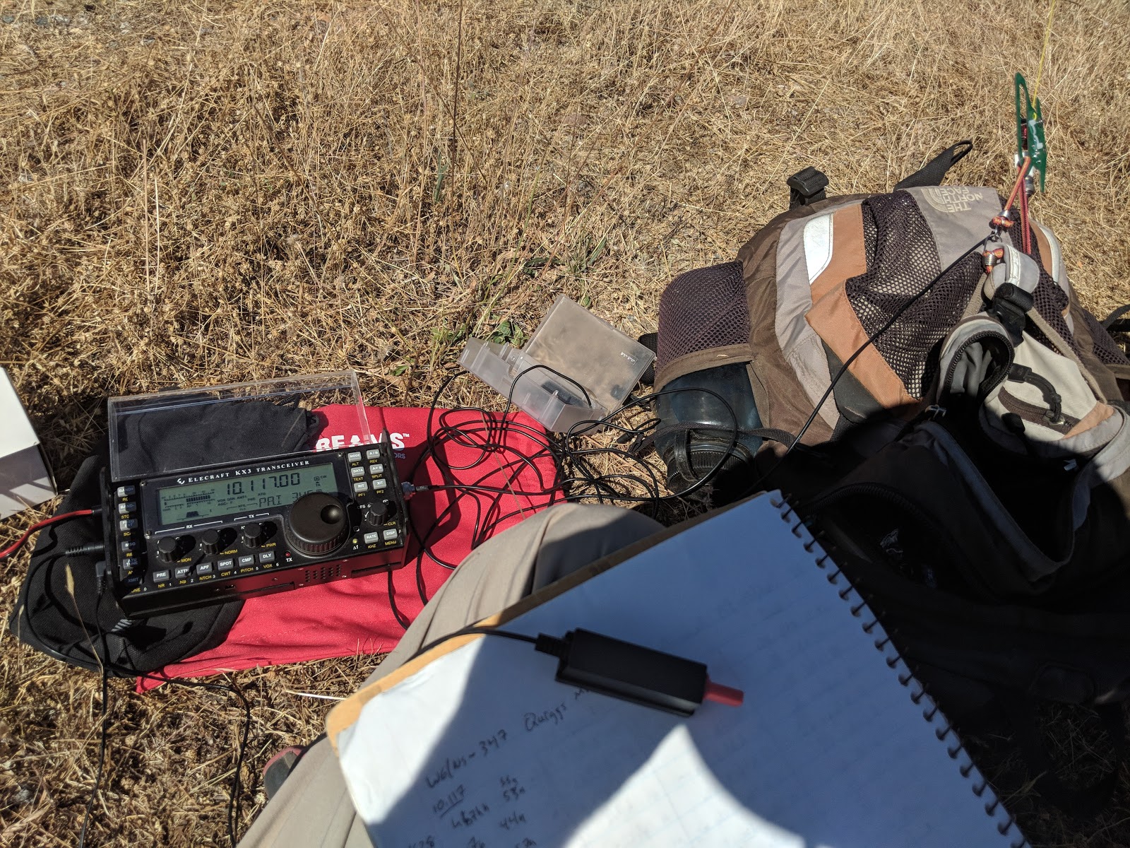
Antenna setup, looking south.
As I was setting up, the sun came out, and it was great. I could see the Sierra crest to the East, and I could make out Mt Diablo in the Bay Area, Mts St Helena, Cobb, and Konockti up in Lake County. With my HT I had no trouble hitting the N6NFI repeater in the Palo Alto foothills. I started on 30 meters, and got 16 contacts. Calling on 20 and 40 resulted in nothing. I also called for a while on VHF and UHF, and was surprised not to get any responses. This seems like it would be a great peak for VHF.
Looking North. The peaks to the left are in the Desolation Wilderness, near Tahoe.
After I was done operating, I just sat around for another two hours enjoying the view. It is easily the best view I've had so far in the Sierra. I could have stayed up there all day, but I knew I had a long hike back to the car. When the sun started threatening to go behind the clouds again, I decided to leave.
Some lakes below the peak.
I retraced my steps back down the ridge and to the trail. I found the trail again a little above where I had left it, and started following it back. I stopped at the lake again for a break before the 1000' descent to the canyon floor. The entire way down I had been dreading the climb back out of the canyon, but it wasn't as bad as I feared it might be.
One of the meadows I walked by.
Partway up the climb on the other side I heard a large animal crash through the bushes. Not sure what it was, I stopped and made some noise, then cautiously continued up the trail. I came around a bend and saw that it was just a deer, so continued up the trail. The deer wasn't that smart, and kept running down the trail in front of me instead of turning off and running into the woods.
Small peak at the top of the climb back out of the canyon.
Back at the top, it felt like a really long walk out of the woods and back to the road and my campsite, but I made it eventually, tired but pleased with the hike.
My campsite, near the trailhead. I had to keep moving my chair to stay in the shade.
Trailhead: Tanglefoot Trailhead, end of 8N14E. The last section on "E" was a bit sketchy in my sedan, but would have been no problem with a little more clearance.
Website: SOTA Site.
Maps: AA6XA SOTA Hikes map.
Route: Take the trail down into Tanglefoot Canyon, then back up the other side. At around 8000', leave the trail and skirt around the sub-peak, then follow the ridge up to the summit.
Red Tape: None.

Monday, July 9, 2018

W6/NS-375 Stevens Peak

After coming down the use trail from the summit of Red Lake Peak, I continued along the ridge. There is a use trail that goes around the small bumps on the ridge, and I followed it.
The final climb up to the summit.
The use trail made the going easy. I lost it in the final col, but found it again when I was partway up the talus slope. I took me an hour to hike over from Red Lake Peak. At the top I found a register inside an ammo box on the highest peak. There was a nice looking rock for sitting just below the summit, so I setup there.
Looking North to Lake Tahoe.
Again, I had no trouble getting a pileup. As I was finishing up on HF, a couple reached the summit and stopped to ask what I was doing. I told them, then took down the antenna to do some VHF. I made two contacts on 2 meters. It was very windy on the summit, but plenty warm.
The meadow I descended to.
To get back to my car at Carson Pass, I retraced my steps down to the col. I then followed the use trail until it started climbing up. Here I contoured around the side of the hill to the section of slope that looked less steep. There were a few class 2 slopes I had to cross, but nothing too difficult. I then followed this slope down to the meadow at the bottom.
A waterfall I found near the bottom of the slope.
This descent was very pretty, and the walk through the meadow was even better. Lots of flowers were still blooming, adding color to the shades of green. It was dry enough in the meadow that my feet didn't get wet, and I did not see another person until I rejoined the PCT at the top of the meadow.
The Meadow, looking north-west.
Back on the PCT I hiked over the hill and back to the car at the pass. There was a guy feeding thru hikers, and I talked to him for a few minutes before walking over to the information center. At the center they were able to confirm that the road to Tanglefoot Trailhead was passable in my car, which was the starting point for my destination tomorrow, Mokelumne Peak.
The lake where I left the trail to go up Red Lake Peak.
Trailhead: Meiss Sno-Park, Carson Pass.
Website: SOTA Site.
Maps: AA6XA SOTA Hikes map.
Route: From Red Lake Peak, follow the ridge over to the summit. Alternatively, Take the PCT north to the meadow on the other side of the small pass, then go cross country up to the ridge and summit.
Red Tape: None.

W6/NS-062 Red Lake Peak

Day two of my Sierra trip I climbed this peak and nearby Stevens Peak. While camping at the Jeff Davis trailhead, my tent nearly got blown over a few times, and so I didn't sleep well. Consequently, I was up early, and got to the trailhead at Carson Pass early. Both lots at the pass require a $5 fee, which I paid then set off north on the PCT.
The trail was sheltered for the first mile or so.
It was cool and windy, so I hiked at a brisk pace to stay warm. I too the PCT to the top of the small pass, where there is a small lake. Here I turned off the trail and went cross country up to the summit. I was briefly concerned because a false summit was surrounded by cliffs, but I quickly realized that it was a false summit.
Getting closer to the summit. 
At the summit area I walked around a bit to find a good area to set up in. Eventually I found a comfortable seat on the East side of the peak, and set up my end-fed. I'm sure that the very steep slope in that direction helped propagation to the rest of the US.
It was a beautiful day at 10,000 feet.
I quickly got a large pileup on 30, and had some fun working my way through it. I then went up to 20 and 40, and got a few contacts on each. I think a lot of people worked me on 30, so the counts were less on the other bands. Once I was done I packed up my HF gear and walked around to the other side of the peak so I could have better LOS to the central valley and Tahoe areas. I then worked one person on 2 and 440 each.
The ridge over to Stevens Peak.
My next destination was Stevens peak, about 1.5 miles away along a scenic ridge. I found the use trail that headed down the mountain to the north, and followed it. It did a good job going around the steep sections, and the trail petered out once it got to the flat sections.
Looking down at Crater Lake, from the ridge.
Trailhead: Meiss Sno-Park, Carson Pass.
Website: SOTA Site.
Maps: AA6XA SOTA Hikes map.
Route: Take the PCT north to the small col. Turn right, and follow the ridge up to the summit.
Red Tape: None.

W6/NS-136 Thornburg Peak

I had some time off during the July 4 holiday, so I decided to go to the Sierra and get some activations in. I decided to head to the Carson Pass and Highway 88 area, because there are a number of summits here, including some unactivated ones. I left home early on the fourth, and got to the trailhead at the heigh of land on Blue Lakes Road by 10am. There was a faint trail that led over the shoulder of Jeff Davis Peak, then down into the meadow on the other side.
First view of Thornburg Peak, from the shoulder of Jeff Davis Peak.
The trail was very faint as it passed through this low area, but I was able to follow it enough to get to the stream that it follows up to a low pass. From this pass I went cross country. I thought I could be clever and contour around some sub-peaks, but this was a mistake. It was much harder. After passing through some exposed rocks, I rejoined the ridge and has some easier going. Eventually I reached the key col and began my ascent up to the summit.
On the side of one of the sub peak, looking at the destination.
I climbed up the ridge to a rocky outcropping, then decided to go through the woods around the last sub-peak. From the last bit of forest up to the col, then the summit was straightforward and easy. At the summit I looked for a register, but didn't see one.
Looking back to Jeff Davis and Markleeville Peaks from the summit.
I had lunch, then set up my antenna and was on the air. There was good cell service on top, and I had no trouble spotting myself. I quickly got 18 contacts on 30 and 20 meters, then decided to pack up. My original plan was to hit Markleeville Peak and Jeff Davis Peak, and I wanted to leave enough time to get both.
Taking a break on the way back up.
I stayed on the ridge to get back to the trail, and had an easy walk, along with great views. I should have taken this route both directions. I was debating the best way to get up Markleeville, but decided that I wouldn't have time, since it was mid-afternoon already, and I was not acclimated to the elevation. Instead I went straight to Jeff Davis Peak.
From the Jeff Davis Creek meadow.
Trailhead: Height of land, Blue Lakes Road.
Website: SOTA Site.
Maps: AA6XA SOTA Hikes map.
Route: Take the trail over the shoulder of Jeff Davis, down to the meadow on the other side. At the top of the small col, turn right and follow the ridge to the summit.
Red Tape: None.

Tuesday, July 3, 2018

W6/NC-323 Black Point

Black Point is a low foothill of Mt Diablo, and was the third peak of the day for me. I stopped by on my way down from the summit of Mt Diablo and North Peak. I was heading down the Mitchell Canyon Trail, and turned off onto Red Road. About a half mile up the hill is the turnoff for the trail that goes to the summit.
Taking a break in the shade.
I was hot and tired at this point, and had less water than I realized. This narrow, overgrown trail was in the full sun, and felt very steep. I struggled up to the steep sections, taking many more breaks than I usually do. By the time I got to the summit, I just plopped down in the shadiest spot I could see to sit and rest for a few minutes.
Circling vultures. I'm not dead yet.
After drinking most of my remaining water, and eating a bar, I started feeling much better. So, I started to set up the antenna.
North Peak on the left, Diablo on the right. Eagle Peak just behind the pole.
Conveniently, there is a post at the summit, perfect for strapping a pole to. I did this, and strung out the end fed, and was on the air. There were many fewer chasers than earlier in the day, but I didn't have to struggle to get enough contacts. After working everyone I could hear on HF, I tried VHF, but only got one response on 2 meters. Surprisingly, 440 was very noisy.
Getting close to the trailhead again.
I was still hot and tired, so I packed up and headed down the hill for the two mile walk back to the car. The descent was still overgrown, but much easier and shadier than the ascent. Back on Mitchell Canyon Road I walked out, surprised not to see any others. Back at the parking lot there was a little bird helping itself to the dog water.
It was nice to be in the air conditioned car for the drive home, which had very little traffic, thankfully.

Trailhead: Mitchell Canyon Visitors Center.
Website: SOTA Site.
Maps: AA6XA SOTA Hikes map.
Route: Take the trail up Mitchell Canyon to the Black Point Trail. This trail loops over the summit.
Red Tape: None.