Friday, April 14, 2023

W6/SC-417 Harris Benchmark

 I climbed this peak a few years ago, but since I have a park pass, I decided to come back and try a different route. This time I would start on the east side of the park, at the Old Pinnacles Trailhead. When I got to the end of the road just before 8, there was still plenty of parking. The plan was to take the North Wilderness Trail to a canyon at the base of the peak, then follow a fence line up to the ridge, then the ridge around to the summit.

One of the easy stream crossings.

The first mile or so of the hike is pretty pleasant along heavily used trails and with bridges across Chalone Creek. The junction with the North Wilderness Trail is signed, and the first few yards were nice. After this point I didn't see any other people until I got back. 
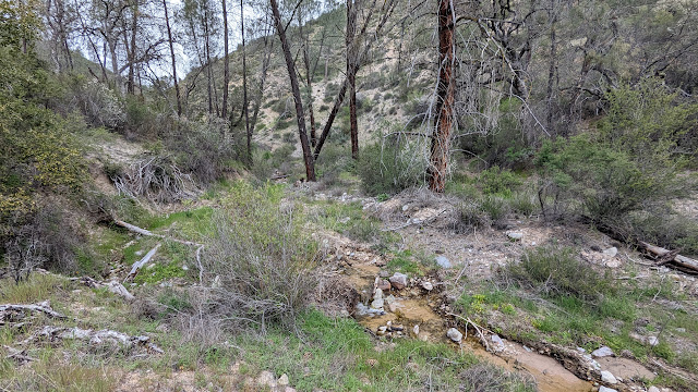
Then the creek crossings started. 
The small tributary creek I followed up the canyon.

The first one wasn't bad. After hiking through some overgrown sections I reached the second. This one was a real pain to get across with mostly dry feet. The rest of the million crossings were varying degrees of bad. I really wished I had brought my poles, they would have helped a lot on some of the crossings. There were a fair number of blowdowns to go over, under, or around as well. The trail could use a maintenance crew coming by.
Fence line at the steam bed.

Overall, the North Wilderness Trail is not a good one to do after a wet winter. It's probably a really nice hike in the fall, before the rain comes. Or during a dry winter. At the northern part of the trail there is a canyon with a small stream that comes in from the north, on the other side of the creek from the trail. I found a down tree to cross Chalone Creek, then followed this canyon up to the fence line.
Made it to the ridge! North Chalone is the pointy one in the distance.

As you're following the small stream, stay to the left so you don't follow an even smaller tributary stream. I made the mistake of following the smaller stream, and had to do some extra bushwhacking. At the fence line, turn right and follow it up to the ridge. This was a pretty easy climb, the brush is clear from the fence. Cross the fence on the ridge, and start the ridge walk.
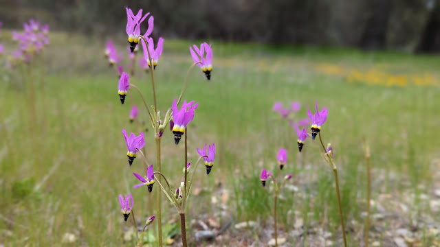
Shooting Star flowers in a meadow.

I had been expecting a pleasant ridge walk on fire breaks and jeep trails, and I was disappointed. There are some sections that are very overgrown and require pushing brush out of the way. It did seem like the brush was slightly less dense in places, so maybe there were breaks in it before that have become overgrown. 
Poppy season.

On the summit I used an old fence to hold up my antenna. I had LTE service on top. Most of the peaks in the park seem to have service but none of the canyons. It had been overcast all day, and I could see some rain in the distance. As I was operating, it started to sprinkle. I stood up to see if there was more rain coming, and it certainly appeared so, so I packed up.
Lupine flowers near the trailhead.

Not too long after I left the summit the rain stopped. I retraced my steps back along the ridge to the fence, and down to the canyon. This time, though, I took the fence line to the main stream. This was a good decision, since the brush was much much less dense here. Back on the trail, it was a long slog with all the stream crossings back to the car. I was, however, able to avoid some of the nearby crossings by simply not crossing. Sadly, the map I had didn't have the accuracy for me to tell on the way in which crossings were superfluous. 
Was this better than the other route I took? I'm not sure. It was certainly longer and the creek crossings were annoying, but not having to climb out of the Chalone Creek bed on the way out was nice. And the crossings wouldn't have been a problem if I had gone later in the season.

Trailhead: Old Pinnacles Trailhead.
Website: SOTA Site.
Route: Take the North Wilderness Trail to the canyon coming from the north near the summit. Follow the canyon to the fence, then the fence to the ridge. Traverse the ridge around to the summit.
Red Tape: None. Standard national park rules.
Video: Coming Soon!

Tuesday, April 4, 2023

W6/CC-039 Viejas Mountain

 This was the second summit of our San Diego Trip. It was an overcast morning near downtown when we woke up. Perfect weather for an exposed hike. We drove up I-5 to Alpine, where we made our way through town to the dirt road that this trail starts from, 15S30. The Corolla we had had no trouble with the dirt road, and we made it to the pullout at the trailhead.

Parking at the trailhead.

With careful parking you could fit quite a few cars here, but maybe only when the giant puddles are dry. The trail starts heading up the hill, and keeps going up the whole way. It is a relatively constant grade, a pretty good one for hiking. We made good time going up. All those hours on the stair master must be paying off.
Looking over at El Cajon mountain.

Eventually the uphill ends and you find yourself on the long summit ridge. It appears this whole area is in the activation zone. We found a spot out of the way and got set up. There was good cell service on top, and spotting was not an issue.
Antenna ready to go.

KN6REU went first. Spots for SOTA and POTA meant she quickly had her four contacts, including France again on 10m. AA6XA did 15m CW, and got a good size pileup that took some time to clear. Since it was lunch time, we had some leftover Pizza Port pizza and cookies on top. A nice change from the sandwiches we usually take.
Looking down at the parking area and Alpine.

The hike down felt long. We passed a decent number of people heading up and down. It seems that this as a relatively popular mountain, and with excellent views of the San Diego area and easy access I can see why. 

Trailhead: Pullout on Forest Road 15S30. This is a continuation of Anderson Road in Alpine.
Website: SOTA Site.
Route: Follow the trail up to the summit.
Red Tape: None.  
Video: Coming Soon!

W6/SD-026

We decided to go down to San Diego for the weekend. After an early flight, we arrived and headed for the hills. Our goal was this unnamed peak near the Mt Laguna recreation area. We had a pleasant drive through the mountains to the trailhead at the Pioneer Mail picnic area. The PCT runs through this area, and we did see some thru hikers, only a few days into their hikes.

Summit from the parking lot.

The trail is across the road from the picnic area. There is a crosswalk at the top of the hill. We crossed, then took the trail that leaves to the right. This briefly parallels the road before turning away and heading up the hill. As you climb onto the base of the ridge, there is an unmarked trail junction. Turn right here and start heading up the ridge.

Summit. If it had been warmer, the pole would have been a good antenna support.

This trail is obviously unmaintained, and it sort of just ends after a while. The brush is sparse enough that it is easy to find a path up. There are even some small cairns marking tricky sections. We had no trouble getting to the summit. It was quite breezy on top, so we found a sheltered area to get set up in. There was good cell service on top. On the bands, 15m was open to Europe, and AA6XA worked Ireland and Portugal. KN6REU worked F4WBN for the first time on 10m, so that was exciting for her.

Trying to make 2m contacts.

 It was getting cool, and also to be lunch time, so we didn't linger too long on top. We took the same route back down to the car. There are so many path options higher up, but near the trail we found the small cairns and junction. Naina was so excited to be going down, she nearly missed the turn to go back to the car. Luckily Jeff wasn't too far behind.

Brush on the way up.

The drive back to San Diego was nice, where we went to Balboa Park for some lunch and walking around. Overall, a great hike and summit.

Trailhead: Keys View.
Website: SOTA Site.
Route: Cross the highway, and take the trail to the right of the driveway. When you get to the spine of the ridge, turn right and take the use trail up to the summit.
Red Tape: None. Parking pass may be required 
Video: Coming Soon!