Monday, June 12, 2023

Pixie 2 Transceiver

 I had a lot of fun making the video series on the Forty-9er, so decided to do something similar with another cheap eBay kit I had in my junk box. I found a Pixie, so the next transceiver was decided. This radio is simple to the point of being almost useless, but it is an interesting design.

The Pixie2

This series I broke into three videos:

As before, there's also an activation video where I put it on the air.

Unlike the Forty-9er, however, I wrote a document that explains things a bit better. And it has the space to go into the math. Everyone could use some more math.
 
Hope you enjoy!

Wednesday, May 24, 2023

Forty-9er Transceiver

 Back in 1996, QRPp (vol. 4 no. 1) published the Forty-9er. This is a forty meter radio designed to run from a 9V battery, hence the name. The circuit was designed by N6KR (of Elecraft fame!), and originally kitted and sold by the NorCal QRP Club. Since then the design has been stolen by Chinese manufacturers who sell kits for cheap.

Forty-9er, as built by AA6XA

This radio is about as simple as you can get and still have a usable transceiver. I broke the Chinese eBay version I had down into six modules. Each has a testing and explanation video on the ham_bitious YouTube channel. The modules are:

There is also a bonus activation video too!
The radio on a SOTA/POTA activation.

I think each of these modules can be built and tested with minimal test gear. I showed some tests that I can do since I acquired a 'scope, but they're certainly not needed to get a working radio.

Hopefully you find the video series informative, and are inspired to go build your own radios!


Monday, May 8, 2023

Sunol Peak W6/NC-244

 Some time recently Pleasanton Ridge regional park was expanded to include the southern part of Sunol Ridge. This is great news for peak baggers and SOTA enthusiasts - there is now a public trail to the summit. The trailhead is the Tyler Ranch Staging Area at the end of Foothill Road in Sunol. There is a large dirt lot with pit toilets.

Looking down at the new parking lot.

There are two trails that head up from here. The shorter paved road, or the dirt trail that rejoins the road at the end of the pavement via a long switchback. I took the switchback up and the road down for some variety. The main trail that runs up and along the ridge is called the Sunol Ridge Trail. Stay on this, and you'll be taken directly to the summit. 
Partway up the steep section.

The forecast was not great for the Friday I went, but I decided to risk it. It was pretty nice below the clouds, but as I climbed it got colder and windier. Around the base of the clouds it even rained a little. There were no views, sadly. Just before the summit I scared some cows out of the way, then reached the paved road that comes up from the west. I took this the last quarter mile or so to the top.
View as I approached the summit.

It was cold and windy, so I walked around the fence surrounding the many towers to try and find somewhere out of the wind. I partially succeeded, but it was a cold activation. There was some sort of HF blackout that morning, and I barely made three contacts on 20-30-40. Luckily I had thrown in my HT just before leaving, so I was able to get enough contacts for the point.
Looking over at Pleasanton Ridge on the way down.

The clouds had lifted some while I was on the summit, so I had some ok views on the way down. The high peaks were still obscured, but I enjoyed what I could see. I also was moving pretty quick, since I was cold after sitting for so long. The hike down was quick, and a real leg workout. Overall, it was a good hike, and I'm glad this new area has been opened.

Trailhead: Tyler Ridge Staging Area
Website: SOTA Site.
Route: Take the Sunol Ridge Trail to the summit.
Red Tape: None.
Video: Coming Soon!

Friday, April 14, 2023

W6/SC-417 Harris Benchmark

 I climbed this peak a few years ago, but since I have a park pass, I decided to come back and try a different route. This time I would start on the east side of the park, at the Old Pinnacles Trailhead. When I got to the end of the road just before 8, there was still plenty of parking. The plan was to take the North Wilderness Trail to a canyon at the base of the peak, then follow a fence line up to the ridge, then the ridge around to the summit.

One of the easy stream crossings.

The first mile or so of the hike is pretty pleasant along heavily used trails and with bridges across Chalone Creek. The junction with the North Wilderness Trail is signed, and the first few yards were nice. After this point I didn't see any other people until I got back. 
Then the creek crossings started. 
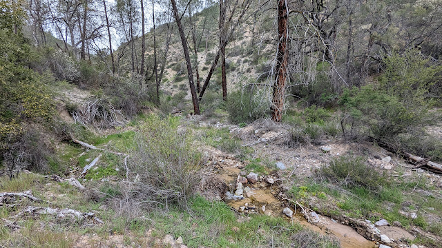
The small tributary creek I followed up the canyon.

The first one wasn't bad. After hiking through some overgrown sections I reached the second. This one was a real pain to get across with mostly dry feet. The rest of the million crossings were varying degrees of bad. I really wished I had brought my poles, they would have helped a lot on some of the crossings. There were a fair number of blowdowns to go over, under, or around as well. The trail could use a maintenance crew coming by.
Fence line at the steam bed.

Overall, the North Wilderness Trail is not a good one to do after a wet winter. It's probably a really nice hike in the fall, before the rain comes. Or during a dry winter. At the northern part of the trail there is a canyon with a small stream that comes in from the north, on the other side of the creek from the trail. I found a down tree to cross Chalone Creek, then followed this canyon up to the fence line.
Made it to the ridge! North Chalone is the pointy one in the distance.

As you're following the small stream, stay to the left so you don't follow an even smaller tributary stream. I made the mistake of following the smaller stream, and had to do some extra bushwhacking. At the fence line, turn right and follow it up to the ridge. This was a pretty easy climb, the brush is clear from the fence. Cross the fence on the ridge, and start the ridge walk.
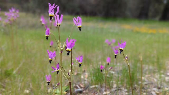
Shooting Star flowers in a meadow.

I had been expecting a pleasant ridge walk on fire breaks and jeep trails, and I was disappointed. There are some sections that are very overgrown and require pushing brush out of the way. It did seem like the brush was slightly less dense in places, so maybe there were breaks in it before that have become overgrown. 
Poppy season.

On the summit I used an old fence to hold up my antenna. I had LTE service on top. Most of the peaks in the park seem to have service but none of the canyons. It had been overcast all day, and I could see some rain in the distance. As I was operating, it started to sprinkle. I stood up to see if there was more rain coming, and it certainly appeared so, so I packed up.
Lupine flowers near the trailhead.

Not too long after I left the summit the rain stopped. I retraced my steps back along the ridge to the fence, and down to the canyon. This time, though, I took the fence line to the main stream. This was a good decision, since the brush was much much less dense here. Back on the trail, it was a long slog with all the stream crossings back to the car. I was, however, able to avoid some of the nearby crossings by simply not crossing. Sadly, the map I had didn't have the accuracy for me to tell on the way in which crossings were superfluous. 
Was this better than the other route I took? I'm not sure. It was certainly longer and the creek crossings were annoying, but not having to climb out of the Chalone Creek bed on the way out was nice. And the crossings wouldn't have been a problem if I had gone later in the season.

Trailhead: Old Pinnacles Trailhead.
Website: SOTA Site.
Route: Take the North Wilderness Trail to the canyon coming from the north near the summit. Follow the canyon to the fence, then the fence to the ridge. Traverse the ridge around to the summit.
Red Tape: None. Standard national park rules.
Video: Coming Soon!

Tuesday, April 4, 2023

W6/CC-039 Viejas Mountain

 This was the second summit of our San Diego Trip. It was an overcast morning near downtown when we woke up. Perfect weather for an exposed hike. We drove up I-5 to Alpine, where we made our way through town to the dirt road that this trail starts from, 15S30. The Corolla we had had no trouble with the dirt road, and we made it to the pullout at the trailhead.

Parking at the trailhead.

With careful parking you could fit quite a few cars here, but maybe only when the giant puddles are dry. The trail starts heading up the hill, and keeps going up the whole way. It is a relatively constant grade, a pretty good one for hiking. We made good time going up. All those hours on the stair master must be paying off.
Looking over at El Cajon mountain.

Eventually the uphill ends and you find yourself on the long summit ridge. It appears this whole area is in the activation zone. We found a spot out of the way and got set up. There was good cell service on top, and spotting was not an issue.
Antenna ready to go.

KN6REU went first. Spots for SOTA and POTA meant she quickly had her four contacts, including France again on 10m. AA6XA did 15m CW, and got a good size pileup that took some time to clear. Since it was lunch time, we had some leftover Pizza Port pizza and cookies on top. A nice change from the sandwiches we usually take.
Looking down at the parking area and Alpine.

The hike down felt long. We passed a decent number of people heading up and down. It seems that this as a relatively popular mountain, and with excellent views of the San Diego area and easy access I can see why. 

Trailhead: Pullout on Forest Road 15S30. This is a continuation of Anderson Road in Alpine.
Website: SOTA Site.
Route: Follow the trail up to the summit.
Red Tape: None.  
Video: Coming Soon!